Brakpan geodata
Brakpan (Gauteng) is a populated place; located in South Africa in Africa/Johannesburg (GMT+2) time zone. With population of 305,692 people, there are 19 cities with bigger population in this country. Compared to other cities in South Africa, 77.6% of cities are located further ↓South; 63.7% of cities are located further ←West and 92.9% of cities have lower elevation than Brakpan. Note1
Administrative division(s):
- Level 1: Gauteng
- Level 2: Ekurhuleni Metropolitan Municipality
- Level 3: Ekurhuleni


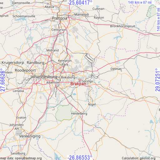
Brakpan GPS coordinates[2]
26° 14' 11.616" South, 28° 22' 9.768" East
| Map corner | latitude | longitude |
|---|---|---|
| Upper-left | -25.60417°, | 27.66626° |
| Center: | -26.23656°, | 28.36938° |
| Lower-right: | -26.86553°, | 29.07251° |
| Map W x H: | 140.3×140.3 km | = 87.2×87.2mi |
| max Lat: | -22.34881° ⇑22.4% North |
| Brakpan: | -26.23656° |
| min Lat: | ⇓77.6% South -34.66739° |
| min Long | Brakpan | max Long |
| 16.8697° | 28.36938° | 32.26762° |
| W 63.7%⇐ | ⇒36.3% E |
Elevation
Elevation of Brakpan is 1631 m = 5351 ft, and this is 661.4 m = 2170 ft above average elevation for this country.
| Max E: |
1873 m = 6145 ft | 7.1% |
| Brakpan | 1631 m 5351 ft | |
| Avg. | 969.6 m = 3181 ft | |
Min E: |
7 m = 23 ft | 92.9% |
See also: Brakpan elevation on elevation.city.
Geographical zone
Brakpan is located in South temperate zone (between Tropic of Capricorn and the Antarctic Circle). Distance of this Southern Tropic circle is 311.3 km =193.4 mi to North.| Distance of | km | miles | from Brakpan |
|---|---|---|---|
| Equator | 2917.2 | 1812.7 | to North |
| Tropic Capricorn | 311.3 | 193.4 | to North |
| Antarctic Circle | 4483.9 | 2786.2 | to South |
| South Pole | 7089.8 | 4405.4 | to South |


Nearby cities:
15 places around Brakpan: (largest is in red/bold)
• Alberton
24.9 km =15.5 mi,  261°
261°
• Benoni
7.2 km =4.5 mi,  317°
317°
• Boksburg
11.3 km =7 mi,  284°
284°
• Delmas
32.9 km =20.4 mi,  72°
72°
• Eastleigh
24.4 km =15.2 mi,  299°
299°
• Eden Glen
23.1 km =14.4 mi, 300°
• Eden Glen Ext 60
23.8 km =14.8 mi, 301°
• Edenvale
24.1 km =15 mi, 296°
• Germiston
19.2 km =11.9 mi,  270°
270°
• Heidelberg
29.8 km =18.5 mi,  181°
181°
• Johannesburg
32.7 km =20.3 mi, 276°
• Modderfontein
26.1 km =16.2 mi,  308°
308°
• Nigel
24.2 km =15 mi,  153°
153°
• Springs
3.4 km =2.1 mi,  116°
116°
• Tembisa
30.3 km =18.8 mi,  331°
331°
Sources, notices
• [Note1] Compared only with cities in South Africa existing in our database
• [Src1] Map data: © OpenStreetMap contributors (CC-BY-SA)
• [Src2] Other city data from geonames.org with taken over terms of usage.
• [Src3] Geographical zone / Annual Mean Temperature by Robert A. Rohde @ Wikipedia
