Nigel geodata
Nigel (Gauteng) is a populated place; located in South Africa in Africa/Johannesburg (GMT+2) time zone. With population of 140,644 people, there are 37 cities with bigger population in this country. Compared to other cities in South Africa, 74.9% of cities are located further ↓South; 64.9% of cities are located further ←West and 86.1% of cities have lower elevation than Nigel. Note1
Administrative division(s):
- Level 1: Gauteng
- Level 2: Ekurhuleni Metropolitan Municipality
- Level 3: Ekurhuleni


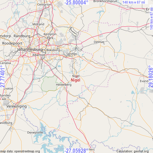
Nigel GPS coordinates[2]
26° 25' 52.968" South, 28° 28' 37.668" East
| Map corner | latitude | longitude |
|---|---|---|
| Upper-left | -25.80004°, | 27.77401° |
| Center: | -26.43138°, | 28.47713° |
| Lower-right: | -27.05928°, | 29.18026° |
| Map W x H: | 140×140 km | = 87×87mi |
| max Lat: | -22.34881° ⇑25.1% North |
| Nigel: | -26.43138° |
| min Lat: | ⇓74.9% South -34.66739° |
| min Long | Nigel | max Long |
| 16.8697° | 28.47713° | 32.26762° |
| W 64.9%⇐ | ⇒35.1% E |
Elevation
Elevation of Nigel is 1566 m = 5138 ft, and this is 596.4 m = 1957 ft above average elevation for this country.
| Max E: |
1873 m = 6145 ft | 13.9% |
| Nigel | 1566 m 5138 ft | |
| Avg. | 969.6 m = 3181 ft | |
Min E: |
7 m = 23 ft | 86.1% |
See also: Nigel elevation on elevation.city.
Geographical zone
Nigel is located in South temperate zone (between Tropic of Capricorn and the Antarctic Circle). Distance of this Southern Tropic circle is 333 km =206.9 mi to North.| Distance of | km | miles | from Nigel |
|---|---|---|---|
| Equator | 2938.9 | 1826.1 | to North |
| Tropic Capricorn | 333 | 206.9 | to North |
| Antarctic Circle | 4462.3 | 2772.7 | to South |
| South Pole | 7068.2 | 4392 | to South |


Nearby cities:
15 places around Nigel: (largest is in red/bold)
• Alberton
39.8 km =24.7 mi,  297°
297°
• Balfour
28.1 km =17.5 mi,  156°
156°
• Benoni
31.2 km =19.4 mi,  330°
330°
• Boksburg
32.6 km =20.3 mi,  318°
318°
• Brakpan
24.2 km =15 mi, 333°
• Delmas
37.7 km =23.4 mi,  32°
32°
• Eastleigh
46.4 km =28.8 mi, 316°
• Eden Glen
45.3 km =28.1 mi, 317°
• Eden Glen Ext 60
46.1 km =28.6 mi, 317°
• Edenvale
45.7 km =28.4 mi,  314°
314°
• Germiston
37.1 km =23.1 mi, 306°
• Heidelberg
14.3 km =8.9 mi,  235°
235°
• Meyerton
47.7 km =29.6 mi,  252°
252°
• Modderfontein
49.1 km =30.5 mi, 320°
• Springs
21.6 km =13.4 mi,  339°
339°
Sources, notices
• [Note1] Compared only with cities in South Africa existing in our database
• [Src1] Map data: © OpenStreetMap contributors (CC-BY-SA)
• [Src2] Other city data from geonames.org with taken over terms of usage.
• [Src3] Geographical zone / Annual Mean Temperature by Robert A. Rohde @ Wikipedia
