Aliwal North geodata
Aliwal North (Eastern Cape) is a seat of a third-order administrative division; located in South Africa in Africa/Johannesburg (GMT+2) time zone. With population of 44,436 people, there are 99 cities with bigger population in this country. Compared to other cities in South Africa, 69.6% of cities are located further ↑North; 63.1% of cities are located further →East and 67% of cities have lower elevation than Aliwal North. Note1
Administrative division(s):
- Level 1: Eastern Cape
- Level 2: Joe Gqabi District Municipality
- Level 3: Maletswai


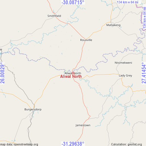
Aliwal North GPS coordinates[2]
30° 41' 37.176" South, 26° 42' 41.076" East
| Map corner | latitude | longitude |
|---|---|---|
| Upper-left | -30.08715°, | 26.00829° |
| Center: | -30.69366°, | 26.71141° |
| Lower-right: | -31.29638°, | 27.41454° |
| Map W x H: | 134.5×134.5 km | = 83.6×83.6mi |
| max Lat: | -22.34881° ⇑69.6% North |
| Aliwal North: | -30.69366° |
| min Lat: | ⇓30.4% South -34.66739° |
| min Long | Aliwal North | max Long |
| 16.8697° | 26.71141° | 32.26762° |
| W 36.9%⇐ | ⇒63.1% E |
Elevation
Elevation of Aliwal North is 1325 m = 4347 ft, and this is 355.4 m = 1166 ft above average elevation for this country.
| Max E: |
1873 m = 6145 ft | 33% |
| Aliwal North | 1325 m 4347 ft | |
| Avg. | 969.6 m = 3181 ft | |
Min E: |
7 m = 23 ft | 67% |
See also: Aliwal North elevation on elevation.city.
Geographical zone
Aliwal North is located in South temperate zone (between Tropic of Capricorn and the Antarctic Circle). Distance of this Southern Tropic circle is 806.9 km =501.4 mi to North.| Distance of | km | miles | from Aliwal North |
|---|---|---|---|
| Equator | 3412.8 | 2120.6 | to North |
| Tropic Capricorn | 806.9 | 501.4 | to North |
| Antarctic Circle | 3988.4 | 2478.3 | to South |
| South Pole | 6594.2 | 4097.4 | to South |


Nearby cities:
15 places around Aliwal North: (largest is in red/bold)
• Barkly East
89.8 km =55.8 mi,  109°
109°
• Burgersdorp
49.8 km =30.9 mi,  227°
227°
• Cala
131.5 km =81.7 mi,  134°
134°
• Dewetsdorp
123.6 km =76.8 mi,  357°
357°
• Dordrecht
82 km =51 mi,  156°
156°
• Elliot
129.7 km =80.6 mi,  123°
123°
• Ilinge
146.1 km =90.8 mi,  167°
167°
• Lady Frere
122.7 km =76.2 mi, 156°
• Lady Grey
48.3 km =30 mi,  92°
92°
• Molteno
85 km =52.8 mi,  203°
203°
• Queensdale
133.3 km =82.8 mi, 169°
• Queenstown
134.8 km =83.8 mi, 173°
• Tarkastad
152.4 km =94.7 mi, 196°
• Trompsburg
115.6 km =71.8 mi,  309°
309°
• Zastron
56.3 km =35 mi,  39°
39°
Sources, notices
• [Note1] Compared only with cities in South Africa existing in our database
• [Src1] Map data: © OpenStreetMap contributors (CC-BY-SA)
• [Src2] Other city data from geonames.org with taken over terms of usage.
• [Src3] Geographical zone / Annual Mean Temperature by Robert A. Rohde @ Wikipedia
