Zastron geodata
Zastron (Orange Free State) is a seat of a third-order administrative division; located in South Africa in Africa/Johannesburg (GMT+2) time zone. With population of 12,449 people, there are 187 cities with bigger population in this country. Compared to other cities in South Africa, 67.3% of cities are located further ↑North; 57.5% of cities are located further →East and 96.2% of cities have lower elevation than Zastron. Note1
Administrative division(s):
- Level 1: Orange Free State
- Level 2: Xhariep District Municipality
- Level 3: Mohokare


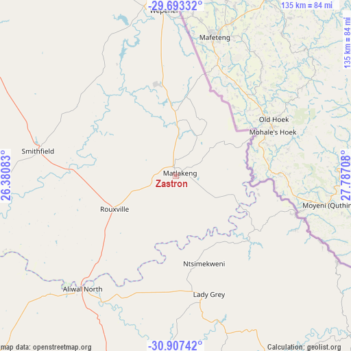
Zastron GPS coordinates[2]
30° 18' 8.1" South, 27° 5' 2.22" East
| Map corner | latitude | longitude |
|---|---|---|
| Upper-left | -29.69332°, | 26.38083° |
| Center: | -30.30225°, | 27.08395° |
| Lower-right: | -30.90742°, | 27.78708° |
| Map W x H: | 135×135 km | = 83.9×83.9mi |
| max Lat: | -22.34881° ⇑67.3% North |
| Zastron: | -30.30225° |
| min Lat: | ⇓32.7% South -34.66739° |
| min Long | Zastron | max Long |
| 16.8697° | 27.08395° | 32.26762° |
| W 42.5%⇐ | ⇒57.5% E |
Elevation
Elevation of Zastron is 1668 m = 5472 ft, and this is 698.4 m = 2291 ft above average elevation for this country.
| Max E: |
1873 m = 6145 ft | 3.8% |
| Zastron | 1668 m 5472 ft | |
| Avg. | 969.6 m = 3181 ft | |
Min E: |
7 m = 23 ft | 96.2% |
See also: South Africa elevation on elevation.city.
Geographical zone
Zastron is located in South temperate zone (between Tropic of Capricorn and the Antarctic Circle). Distance of this Southern Tropic circle is 763.4 km =474.4 mi to North.| Distance of | km | miles | from Zastron |
|---|---|---|---|
| Equator | 3369.3 | 2093.6 | to North |
| Tropic Capricorn | 763.4 | 474.4 | to North |
| Antarctic Circle | 4031.9 | 2505.3 | to South |
| South Pole | 6637.8 | 4124.5 | to South |


Nearby cities:
15 places around Zastron: (largest is in red/bold)
• Aliwal North
56.3 km =35 mi,  219°
219°
• Barkly East
88.8 km =55.2 mi,  146°
146°
• Bloemfontein
155.9 km =96.9 mi,  327°
327°
• Botshabelo
120.1 km =74.6 mi,  343°
343°
• Burgersdorp
105.8 km =65.7 mi, 223°
• Cala
147.8 km =91.8 mi,  156°
156°
• Dewetsdorp
89.6 km =55.7 mi, 333°
• Dordrecht
119 km =73.9 mi,  181°
181°
• Elliot
136 km =84.5 mi, 147°
• Lady Grey
47.2 km =29.3 mi, 164°
• Ladybrand
128.3 km =79.7 mi,  16°
16°
• Maclear
148.3 km =92.1 mi,  125°
125°
• Molteno
139.8 km =86.9 mi,  209°
209°
• Thaba Nchu
123.8 km =76.9 mi,  348°
348°
• Trompsburg
128.8 km =80 mi,  283°
283°
Sources, notices
• [Note1] Compared only with cities in South Africa existing in our database
• [Src1] Map data: © OpenStreetMap contributors (CC-BY-SA)
• [Src2] Other city data from geonames.org with taken over terms of usage.
• [Src3] Geographical zone / Annual Mean Temperature by Robert A. Rohde @ Wikipedia
