Trompsburg geodata
Trompsburg (Orange Free State) is a seat of a second-order administrative division; located in South Africa in Africa/Johannesburg (GMT+2) time zone. In our database, there are 257 cities with bigger population. Compared to other cities in South Africa, 65.8% of cities are located further ↑North; 69.3% of cities are located further →East and 74.6% of cities have lower elevation than Trompsburg. Note1
Administrative division(s):
- Level 1: Orange Free State
- Level 2: Xhariep District Municipality
- Level 3: Kopanong


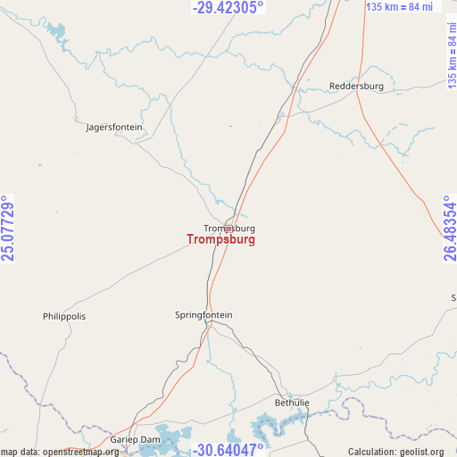
Trompsburg GPS coordinates[2]
30° 2' 1.068" South, 25° 46' 49.476" East
| Map corner | latitude | longitude |
|---|---|---|
| Upper-left | -29.42305°, | 25.07729° |
| Center: | -30.03363°, | 25.78041° |
| Lower-right: | -30.64047°, | 26.48354° |
| Map W x H: | 135.4×135.4 km | = 84.1×84.1mi |
| max Lat: | -22.34881° ⇑65.8% North |
| Trompsburg: | -30.03363° |
| min Lat: | ⇓34.2% South -34.66739° |
| min Long | Trompsburg | max Long |
| 16.8697° | 25.78041° | 32.26762° |
| W 30.7%⇐ | ⇒69.3% E |
Elevation
Elevation of Trompsburg is 1418 m = 4652 ft, and this is 448.4 m = 1471 ft above average elevation for this country.
| Max E: |
1873 m = 6145 ft | 25.4% |
| Trompsburg | 1418 m 4652 ft | |
| Avg. | 969.6 m = 3181 ft | |
Min E: |
7 m = 23 ft | 74.6% |
See also: South Africa elevation on elevation.city.
Geographical zone
Trompsburg is located in South temperate zone (between Tropic of Capricorn and the Antarctic Circle). Distance of this Southern Tropic circle is 733.5 km =455.8 mi to North.| Distance of | km | miles | from Trompsburg |
|---|---|---|---|
| Equator | 3339.4 | 2075 | to North |
| Tropic Capricorn | 733.5 | 455.8 | to North |
| Antarctic Circle | 4061.7 | 2523.8 | to South |
| South Pole | 6667.6 | 4143.1 | to South |


Nearby cities:
15 places around Trompsburg: (largest is in red/bold)
• Aliwal North
115.6 km =71.8 mi,  129°
129°
• Bloemfontein
109.8 km =68.2 mi,  22°
22°
• Botshabelo
124.9 km =77.6 mi,  47°
47°
• Burgersdorp
119.4 km =74.2 mi,  153°
153°
• Colesberg
100.6 km =62.5 mi,  220°
220°
• Dewetsdorp
99 km =61.5 mi,  59°
59°
• Koffiefontein
102.4 km =63.6 mi,  312°
312°
• Lady Grey
157 km =97.6 mi,  118°
118°
• Molteno
161.5 km =100.4 mi,  159°
159°
• Noupoort
150.9 km =93.8 mi,  211°
211°
• Orania
134.1 km =83.3 mi,  280°
280°
• Petrusville
108 km =67.1 mi,  267°
267°
• Ritchie
158.8 km =98.7 mi, 314°
• Thaba Nchu
137.4 km =85.4 mi, 48°
• Zastron
128.8 km =80 mi,  103°
103°
Sources, notices
• [Note1] Compared only with cities in South Africa existing in our database
• [Src1] Map data: © OpenStreetMap contributors (CC-BY-SA)
• [Src2] Other city data from geonames.org with taken over terms of usage.
• [Src3] Geographical zone / Annual Mean Temperature by Robert A. Rohde @ Wikipedia
