Velabisht geodata
Velabisht (Berat) is a seat of a third-order administrative division; located in Albania in Europe/Tirane (GMT+2) time zone. In our database, there are 71 cities with bigger population. Compared to other cities in Albania, 72.7% of cities are located further ↑North; 54.1% of cities are located further →East and 73.5% of cities have higher elevation than Velabisht. Note1


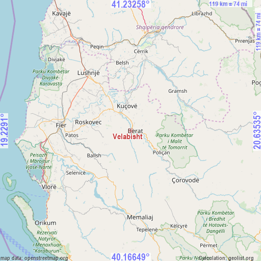
Velabisht GPS coordinates[2]
40° 42' 6.012" North, 19° 55' 55.992" East
| Map corner | latitude | longitude |
|---|---|---|
| Upper-left | 41.23258°, | 19.2291° |
| Center: | 40.70167°, | 19.93222° |
| Lower-right: | 40.16649°, | 20.63535° |
| Map W x H: | 118.5×118.5 km | = 73.6×73.6mi |
| max Lat: | 42.45139° ⇑72.7% North |
| Velabisht: | 40.70167° |
| min Lat: | ⇓27.3% South 39.65889° |
| min Long | Velabisht | max Long |
| 19.40556° | 19.93222° | 20.99° |
| W 45.9%⇐ | ⇒54.1% E |
Elevation
Elevation of Velabisht is 60 m = 197 ft, and this is 314.6 m = 1032 ft below average elevation for this country.
| Max E: |
1352 m = 4436 ft | 73.5% |
| Avg. | 374.6 m = 1229 ft | |
| Velabisht | 60 m = 197 ft | |
Min E: |
-2 m = -7 ft | 26.5% |
See also: Albania elevation on elevation.city.
Geographical zone
Velabisht is located in North temperate zone (between Tropic of Cancer and the Arctic Circle). Distance of this Northern Tropic circle is 1919.7 km =1192.8 mi to South.| Distance of | km | miles | from Velabisht |
|---|---|---|---|
| North Pole | 5481.5 | 3406 | to North |
| Arctic Circle | 2875.6 | 1786.8 | to North |
| Tropic Cancer | 1919.7 | 1192.8 | to South |
| Equator | 4525.6 | 2812.1 | to South |


Nearby cities:
15 places around Velabisht: (largest is in red/bold)
• Banaj
15.7 km =9.8 mi,  330°
330°
• Berat
1.7 km =1.1 mi,  74°
74°
• Cukalat
12.4 km =7.7 mi,  284°
284°
• Dushk
15 km =9.3 mi, 280°
• Kozarë
14.6 km =9.1 mi,  349°
349°
• Kutalli
15.3 km =9.5 mi,  306°
306°
• Kuçovë
11 km =6.8 mi, 353°
• Ngraçan
13.4 km =8.3 mi,  241°
241°
• Otllak
4.7 km =2.9 mi,  3°
3°
• Perondi
8.6 km =5.3 mi, 354°
• Poshnje
11.5 km =7.1 mi,  319°
319°
• Roshnik
9.7 km =6 mi, 69°
• Sinjë
8.1 km =5 mi,  222°
222°
• Ura Vajgurore
8.8 km =5.5 mi, 328°
• Vërtop
13.1 km =8.1 mi,  128°
128°
Sources, notices
• [Note1] Compared only with cities in Albania existing in our database
• [Src1] Map data: © OpenStreetMap contributors (CC-BY-SA)
• [Src2] Other city data from geonames.org with taken over terms of usage.
• [Src3] Geographical zone / Annual Mean Temperature by Robert A. Rohde @ Wikipedia
