Kuçovë geodata
Kuçovë (Berat) is a seat of a second-order administrative division; located in Albania in Europe/Tirane (GMT+2) time zone. With population of 18,166 people, there are 18 cities with bigger population in this country. Compared to other cities in Albania, 63.9% of cities are located further ↑North; 55.5% of cities are located further →East and 74.4% of cities have higher elevation than Kuçovë. Note1


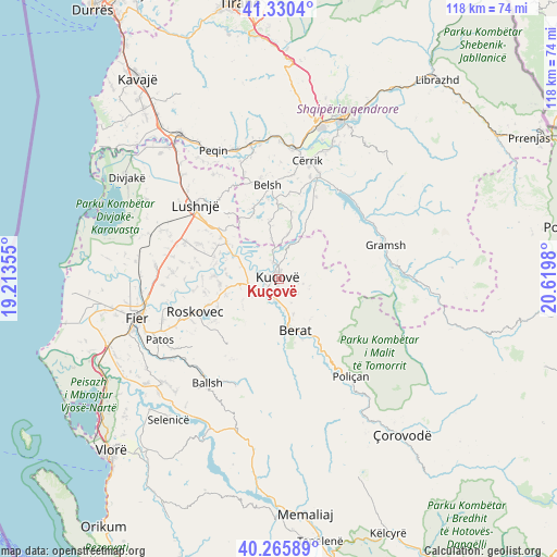
Kuçovë GPS coordinates[2]
40° 48' 1.008" North, 19° 55' 0.012" East
| Map corner | latitude | longitude |
|---|---|---|
| Upper-left | 41.3304°, | 19.21355° |
| Center: | 40.80028°, | 19.91667° |
| Lower-right: | 40.26589°, | 20.6198° |
| Map W x H: | 118.4×118.4 km | = 73.6×73.6mi |
| max Lat: | 42.45139° ⇑63.9% North |
| Kuçovë: | 40.80028° |
| min Lat: | ⇓36.1% South 39.65889° |
| min Long | Kuçovë | max Long |
| 19.40556° | 19.91667° | 20.99° |
| W 44.5%⇐ | ⇒55.5% E |
Elevation
Elevation of Kuçovë is 58 m = 190 ft, and this is 316.6 m = 1039 ft below average elevation for this country.
| Max E: |
1352 m = 4436 ft | 74.4% |
| Avg. | 374.6 m = 1229 ft | |
| Kuçovë | 58 m = 190 ft | |
Min E: |
-2 m = -7 ft | 25.6% |
See also: Albania elevation on elevation.city.
Geographical zone
Kuçovë is located in North temperate zone (between Tropic of Cancer and the Arctic Circle). Distance of this Northern Tropic circle is 1930.6 km =1199.6 mi to South.| Distance of | km | miles | from Kuçovë |
|---|---|---|---|
| North Pole | 5470.5 | 3399.2 | to North |
| Arctic Circle | 2864.6 | 1780 | to North |
| Tropic Cancer | 1930.6 | 1199.6 | to South |
| Equator | 4536.6 | 2818.9 | to South |


Nearby cities:
15 places around Kuçovë: (largest is in red/bold)
• Banaj
7 km =4.3 mi,  293°
293°
• Berat
10.9 km =6.8 mi,  164°
164°
• Cukalat
13.2 km =8.2 mi,  233°
233°
• Fier-Shegan
13.3 km =8.3 mi,  303°
303°
• Fierzë
14.6 km =9.1 mi,  336°
336°
• Grekan
14.6 km =9.1 mi,  10°
10°
• Kajan
12.9 km =8 mi,  349°
349°
• Kozarë
3.7 km =2.3 mi, 338°
• Kutalli
11.1 km =6.9 mi,  260°
260°
• Otllak
6.5 km =4 mi,  165°
165°
• Perondi
2.4 km =1.5 mi, 167°
• Poshnje
6.5 km =4 mi,  249°
249°
• Roshnik
12.8 km =8 mi,  125°
125°
• Ura Vajgurore
4.8 km =3 mi,  223°
223°
• Velabisht
11 km =6.8 mi, 173°
Sources, notices
• [Note1] Compared only with cities in Albania existing in our database
• [Src1] Map data: © OpenStreetMap contributors (CC-BY-SA)
• [Src2] Other city data from geonames.org with taken over terms of usage.
• [Src3] Geographical zone / Annual Mean Temperature by Robert A. Rohde @ Wikipedia
