Kozarë geodata
Kozarë (Berat) is a seat of a third-order administrative division; located in Albania in Europe/Tirane (GMT+2) time zone. In our database, there are 71 cities with bigger population. Compared to other cities in Albania, 62.5% of cities are located further ↑North; 56.6% of cities are located further →East and 83.9% of cities have higher elevation than Kozarë. Note1


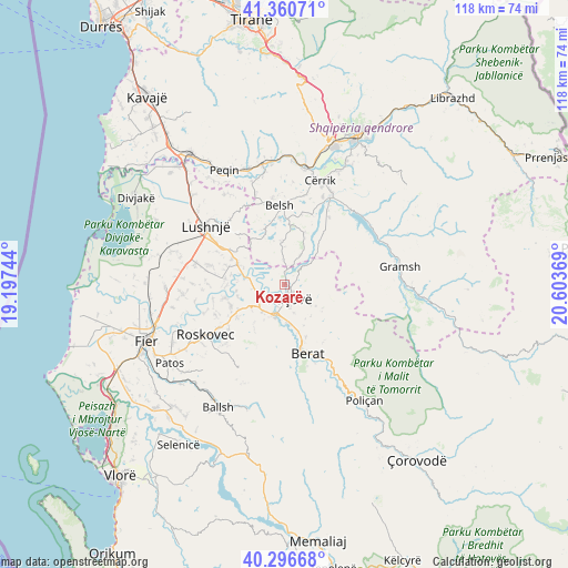
Kozarë GPS coordinates[2]
40° 49' 50.988" North, 19° 54' 2.016" East
| Map corner | latitude | longitude |
|---|---|---|
| Upper-left | 41.36071°, | 19.19744° |
| Center: | 40.83083°, | 19.90056° |
| Lower-right: | 40.29668°, | 20.60369° |
| Map W x H: | 118.3×118.3 km | = 73.5×73.5mi |
| max Lat: | 42.45139° ⇑62.5% North |
| Kozarë: | 40.83083° |
| min Lat: | ⇓37.5% South 39.65889° |
| min Long | Kozarë | max Long |
| 19.40556° | 19.90056° | 20.99° |
| W 43.4%⇐ | ⇒56.6% E |
Elevation
Elevation of Kozarë is 28 m = 92 ft, and this is 346.6 m = 1137 ft below average elevation for this country.
| Max E: |
1352 m = 4436 ft | 83.9% |
| Avg. | 374.6 m = 1229 ft | |
| Kozarë | 28 m = 92 ft | |
Min E: |
-2 m = -7 ft | 16.1% |
See also: Albania elevation on elevation.city.
Geographical zone
Kozarë is located in North temperate zone (between Tropic of Cancer and the Arctic Circle). Distance of this Northern Tropic circle is 1934 km =1201.7 mi to South.| Distance of | km | miles | from Kozarë |
|---|---|---|---|
| North Pole | 5467.1 | 3397.1 | to North |
| Arctic Circle | 2861.2 | 1777.9 | to North |
| Tropic Cancer | 1934 | 1201.7 | to South |
| Equator | 4540 | 2821 | to South |


Nearby cities:
15 places around Kozarë: (largest is in red/bold)
• Allkaj
12.6 km =7.8 mi,  283°
283°
• Banaj
5.1 km =3.2 mi,  262°
262°
• Berat
14.6 km =9.1 mi,  162°
162°
• Cukalat
14.5 km =9 mi,  219°
219°
• Fier-Shegan
10.5 km =6.5 mi,  292°
292°
• Fierzë
10.9 km =6.8 mi,  335°
335°
• Grekan
11.7 km =7.3 mi,  19°
19°
• Kajan
9.3 km =5.8 mi,  354°
354°
• Kutalli
10.9 km =6.8 mi,  241°
241°
• Kuçovë
3.7 km =2.3 mi, 158°
• Mollas
13.8 km =8.6 mi,  39°
39°
• Otllak
10.1 km =6.3 mi, 163°
• Perondi
6.1 km =3.8 mi, 161°
• Poshnje
7.4 km =4.6 mi, 220°
• Ura Vajgurore
7.1 km =4.4 mi,  195°
195°
Sources, notices
• [Note1] Compared only with cities in Albania existing in our database
• [Src1] Map data: © OpenStreetMap contributors (CC-BY-SA)
• [Src2] Other city data from geonames.org with taken over terms of usage.
• [Src3] Geographical zone / Annual Mean Temperature by Robert A. Rohde @ Wikipedia
