Memaliaj geodata
Memaliaj (Gjirokastër) is a seat of a third-order administrative division; located in Albania in Europe/Tirane (GMT+2) time zone. With population of 4,951 people, there are 45 cities with bigger population in this country. Compared to other cities in Albania, 89% of cities are located further ↑North; 50.7% of cities are located further →East and 65.9% of cities have higher elevation than Memaliaj. Note1


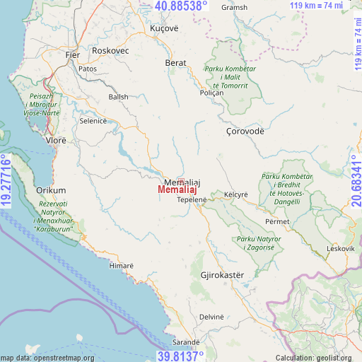
Memaliaj GPS coordinates[2]
40° 21' 6.012" North, 19° 58' 49.008" East
| Map corner | latitude | longitude |
|---|---|---|
| Upper-left | 40.88538°, | 19.27716° |
| Center: | 40.35167°, | 19.98028° |
| Lower-right: | 39.8137°, | 20.68341° |
| Map W x H: | 119.2×119.2 km | = 74.1×74.1mi |
| max Lat: | 42.45139° ⇑89% North |
| Memaliaj: | 40.35167° |
| min Lat: | ⇓11% South 39.65889° |
| min Long | Memaliaj | max Long |
| 19.40556° | 19.98028° | 20.99° |
| W 49.3%⇐ | ⇒50.7% E |
Elevation
Elevation of Memaliaj is 115 m = 377 ft, and this is 259.6 m = 852 ft below average elevation for this country.
| Max E: |
1352 m = 4436 ft | 65.9% |
| Avg. | 374.6 m = 1229 ft | |
| Memaliaj | 115 m = 377 ft | |
Min E: |
-2 m = -7 ft | 34.1% |
See also: Albania elevation on elevation.city.
Geographical zone
Memaliaj is located in North temperate zone (between Tropic of Cancer and the Arctic Circle). Distance of this Northern Tropic circle is 1880.8 km =1168.7 mi to South.| Distance of | km | miles | from Memaliaj |
|---|---|---|---|
| North Pole | 5520.4 | 3430.2 | to North |
| Arctic Circle | 2914.5 | 1811 | to North |
| Tropic Cancer | 1880.8 | 1168.7 | to South |
| Equator | 4486.7 | 2787.9 | to South |


Nearby cities:
15 places around Memaliaj: (largest is in red/bold)
• Ballaban
14.9 km =9.3 mi,  61°
61°
• Buz
10.6 km =6.6 mi,  11°
11°
• Fratar
21.5 km =13.4 mi,  319°
319°
• Krahës
15 km =9.3 mi,  310°
310°
• Kutë
22.6 km =14 mi, 306°
• Këlcyrë
18.2 km =11.3 mi,  103°
103°
• Luftinjë
10.4 km =6.5 mi,  347°
347°
• Picar
21.4 km =13.3 mi,  164°
164°
• Progonat
15.7 km =9.8 mi,  191°
191°
• Selitë
24.5 km =15.2 mi,  332°
332°
• Sevaster
21.8 km =13.5 mi,  283°
283°
• Sukë
15 km =9.3 mi,  79°
79°
• Tepelenë
7 km =4.3 mi,  152°
152°
• Topojan
19.9 km =12.4 mi, 81°
• Vendresha e Vogël
21.7 km =13.5 mi,  37°
37°
Sources, notices
• [Note1] Compared only with cities in Albania existing in our database
• [Src1] Map data: © OpenStreetMap contributors (CC-BY-SA)
• [Src2] Other city data from geonames.org with taken over terms of usage.
• [Src3] Geographical zone / Annual Mean Temperature by Robert A. Rohde @ Wikipedia
