Progonat geodata
Progonat (Gjirokastër) is a seat of a third-order administrative division; located in Albania in Europe/Tirane (GMT+2) time zone. In our database, there are 71 cities with bigger population. Compared to other cities in Albania, 91.5% of cities are located further ↑North; 53.5% of cities are located further →East and 92.4% of cities have lower elevation than Progonat. Note1


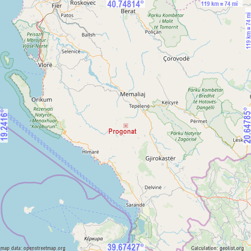
Progonat GPS coordinates[2]
40° 12' 47.988" North, 19° 56' 40.992" East
| Map corner | latitude | longitude |
|---|---|---|
| Upper-left | 40.74814°, | 19.2416° |
| Center: | 40.21333°, | 19.94472° |
| Lower-right: | 39.67427°, | 20.64785° |
| Map W x H: | 119.4×119.4 km | = 74.2×74.2mi |
| max Lat: | 42.45139° ⇑91.5% North |
| Progonat: | 40.21333° |
| min Lat: | ⇓8.5% South 39.65889° |
| min Long | Progonat | max Long |
| 19.40556° | 19.94472° | 20.99° |
| W 46.5%⇐ | ⇒53.5% E |
Elevation
Elevation of Progonat is 926 m = 3038 ft, and this is 551.4 m = 1809 ft above average elevation for this country.
| Max E: |
1352 m = 4436 ft | 7.6% |
| Progonat | 926 m 3038 ft | |
| Avg. | 374.6 m = 1229 ft | |
Min E: |
-2 m = -7 ft | 92.4% |
See also: Albania elevation on elevation.city.
Geographical zone
Progonat is located in North temperate zone (between Tropic of Cancer and the Arctic Circle). Distance of this Northern Tropic circle is 1865.4 km =1159.1 mi to South.| Distance of | km | miles | from Progonat |
|---|---|---|---|
| North Pole | 5535.8 | 3439.8 | to North |
| Arctic Circle | 2929.9 | 1820.6 | to North |
| Tropic Cancer | 1865.4 | 1159.1 | to South |
| Equator | 4471.3 | 2778.3 | to South |


Nearby cities:
15 places around Progonat: (largest is in red/bold)
• Brataj
24.2 km =15 mi,  284°
284°
• Gjirokastër
22.5 km =14 mi,  132°
132°
• Himarë
21 km =13 mi,  233°
233°
• Kardhiq
12.4 km =7.7 mi,  145°
145°
• Këlcyrë
23.5 km =14.6 mi,  61°
61°
• Lazarat
25.3 km =15.7 mi,  137°
137°
• Lukovë
24.7 km =15.3 mi,  186°
186°
• Memaliaj
15.7 km =9.8 mi,  11°
11°
• Odrie
20.8 km =12.9 mi,  115°
115°
• Picar
10.2 km =6.3 mi, 120°
• Qestorat
24.1 km =15 mi, 116°
• Sukë
25.3 km =15.7 mi,  44°
44°
• Tepelenë
11.1 km =6.9 mi,  34°
34°
• Vergo
23.6 km =14.7 mi,  166°
166°
• Vranisht
21.6 km =13.4 mi,  268°
268°
Sources, notices
• [Note1] Compared only with cities in Albania existing in our database
• [Src1] Map data: © OpenStreetMap contributors (CC-BY-SA)
• [Src2] Other city data from geonames.org with taken over terms of usage.
• [Src3] Geographical zone / Annual Mean Temperature by Robert A. Rohde @ Wikipedia
