Himarë geodata
Himarë (Vlorë) is a seat of a third-order administrative division; located in Albania in Europe/Tirane (GMT+2) time zone. With population of 4,596 people, there are 48 cities with bigger population in this country. Compared to other cities in Albania, 95.2% of cities are located further ↑North; 71.5% of cities are located further →East and 98.6% of cities have higher elevation than Himarë. Note1


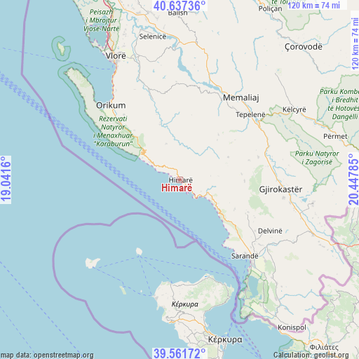
Himarë GPS coordinates[2]
40° 6' 6.012" North, 19° 44' 40.992" East
| Map corner | latitude | longitude |
|---|---|---|
| Upper-left | 40.63736°, | 19.0416° |
| Center: | 40.10167°, | 19.74472° |
| Lower-right: | 39.56172°, | 20.44785° |
| Map W x H: | 119.6×119.6 km | = 74.3×74.3mi |
| max Lat: | 42.45139° ⇑95.2% North |
| Himarë: | 40.10167° |
| min Lat: | ⇓4.8% South 39.65889° |
| min Long | Himarë | max Long |
| 19.40556° | 19.74472° | 20.99° |
| W 28.5%⇐ | ⇒71.5% E |
Elevation
Elevation of Himarë is 3 m = 10 ft, and this is 371.6 m = 1219 ft below average elevation for this country.
| Max E: |
1352 m = 4436 ft | 98.6% |
| Avg. | 374.6 m = 1229 ft | |
| Himarë | 3 m = 10 ft | |
Min E: |
-2 m = -7 ft | 1.4% |
See also: Albania elevation on elevation.city.
Geographical zone
Himarë is located in North temperate zone (between Tropic of Cancer and the Arctic Circle). Distance of this Northern Tropic circle is 1853 km =1151.4 mi to South.| Distance of | km | miles | from Himarë |
|---|---|---|---|
| North Pole | 5548.2 | 3447.5 | to North |
| Arctic Circle | 2942.3 | 1828.3 | to North |
| Tropic Cancer | 1853 | 1151.4 | to South |
| Equator | 4458.9 | 2770.6 | to South |


Nearby cities:
15 places around Himarë: (largest is in red/bold)
• Brataj
19.6 km =12.2 mi,  340°
340°
• Delvinë
34.4 km =21.4 mi,  119°
119°
• Gjirokastër
33.7 km =20.9 mi,  94°
94°
• Kardhiq
24.1 km =15 mi,  84°
84°
• Kotë
34.2 km =21.3 mi, 339°
• Lukovë
18.9 km =11.7 mi,  130°
130°
• Memaliaj
34.2 km =21.3 mi,  35°
35°
• Orikum
34 km =21.1 mi,  316°
316°
• Picar
26.8 km =16.7 mi,  74°
74°
• Progonat
21 km =13 mi,  53°
53°
• Sarandë
33.5 km =20.8 mi,  138°
138°
• Sevaster
32.8 km =20.4 mi,  357°
357°
• Tepelenë
31.8 km =19.8 mi, 47°
• Vergo
24.8 km =15.4 mi, 115°
• Vranisht
12.9 km =8 mi, 339°
Sources, notices
• [Note1] Compared only with cities in Albania existing in our database
• [Src1] Map data: © OpenStreetMap contributors (CC-BY-SA)
• [Src2] Other city data from geonames.org with taken over terms of usage.
• [Src3] Geographical zone / Annual Mean Temperature by Robert A. Rohde @ Wikipedia
