Tepelenë geodata
Tepelenë (Gjirokastër) is a seat of a second-order administrative division; located in Albania in Europe/Tirane (GMT+2) time zone. With population of 11,955 people, there are 27 cities with bigger population in this country. Compared to other cities in Albania, 90.1% of cities are located further ↑North; 53.5% of cities are located further ←West and 55.8% of cities have higher elevation than Tepelenë. Note1


Tepelenë GPS coordinates[2]
40° 17' 44.988" North, 20° 1' 9.012" East
| Map corner | latitude | longitude |
|---|---|---|
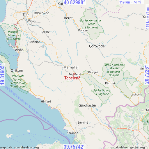
| Upper-left | 40.82998°, | 19.31605° |
| Center: | 40.29583°, | 20.01917° |
| Lower-right: | 39.75742°, | 20.7223° |
| Map W x H: | 119.3×119.3 km | = 74.1×74.1mi |
| max Lat: | 42.45139° ⇑90.1% North |
| Tepelenë: | 40.29583° |
| min Lat: | ⇓9.9% South 39.65889° |
| min Long | Tepelenë | max Long |
| 19.40556° | 20.01917° | 20.99° |
| W 53.5%⇐ | ⇒46.5% E |
Elevation
Elevation of Tepelenë is 212 m = 696 ft, and this is 162.6 m = 533 ft below average elevation for this country.
| Max E: |
1352 m = 4436 ft | 55.8% |
| Avg. | 374.6 m = 1229 ft | |
| Tepelenë | 212 m = 696 ft | |
Min E: |
-2 m = -7 ft | 44.2% |
See also: Albania elevation on elevation.city.
Geographical zone
Tepelenë is located in North temperate zone (between Tropic of Cancer and the Arctic Circle). Distance of this Northern Tropic circle is 1874.6 km =1164.8 mi to South.| Distance of | km | miles | from Tepelenë |
|---|---|---|---|
| North Pole | 5526.6 | 3434.1 | to North |
| Arctic Circle | 2920.7 | 1814.8 | to North |
| Tropic Cancer | 1874.6 | 1164.8 | to South |
| Equator | 4480.5 | 2784.1 | to South |


Nearby cities:
15 places around Tepelenë: (largest is in red/bold)
• Ballaban
16.6 km =10.3 mi,  36°
36°
• Buz
16.6 km =10.3 mi,  355°
355°
• Kardhiq
19.4 km =12.1 mi,  177°
177°
• Krahës
21.7 km =13.5 mi,  317°
317°
• Këlcyrë
14.6 km =9.1 mi,  82°
82°
• Luftinjë
17.2 km =10.7 mi,  341°
341°
• Memaliaj
7 km =4.3 mi,  332°
332°
• Odrie
22 km =13.7 mi,  145°
145°
• Picar
14.6 km =9.1 mi,  170°
170°
• Piskovë
21.6 km =13.4 mi,  94°
94°
• Progonat
11.1 km =6.9 mi,  214°
214°
• Sukë
14.5 km =9 mi,  52°
52°
• Topojan
18.8 km =11.7 mi,  61°
61°
• Vithkuq
22.8 km =14.2 mi,  116°
116°
• Çepan
24.7 km =15.3 mi, 55°
Sources, notices
• [Note1] Compared only with cities in Albania existing in our database
• [Src1] Map data: © OpenStreetMap contributors (CC-BY-SA)
• [Src2] Other city data from geonames.org with taken over terms of usage.
• [Src3] Geographical zone / Annual Mean Temperature by Robert A. Rohde @ Wikipedia
