Mamurras geodata
Mamurras (Lezhë) is a seat of a third-order administrative division; located in Albania in Europe/Tirane (GMT+2) time zone. With population of 8,282 people, there are 36 cities with bigger population in this country. Compared to other cities in Albania, 74.1% of cities are located further ↓South; 77.2% of cities are located further →East and 84.8% of cities have higher elevation than Mamurras. Note1


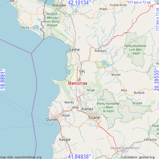
Mamurras GPS coordinates[2]
41° 34' 39" North, 19° 41' 31.992" East
| Map corner | latitude | longitude |
|---|---|---|
| Upper-left | 42.10134°, | 18.9891° |
| Center: | 41.5775°, | 19.69222° |
| Lower-right: | 41.04938°, | 20.39535° |
| Map W x H: | 117×117 km | = 72.7×72.7mi |
| max Lat: | 42.45139° ⇑25.9% North |
| Mamurras: | 41.5775° |
| min Lat: | ⇓74.1% South 39.65889° |
| min Long | Mamurras | max Long |
| 19.40556° | 19.69222° | 20.99° |
| W 22.8%⇐ | ⇒77.2% E |
Elevation
Elevation of Mamurras is 25 m = 82 ft, and this is 349.6 m = 1147 ft below average elevation for this country.
| Max E: |
1352 m = 4436 ft | 84.8% |
| Avg. | 374.6 m = 1229 ft | |
| Mamurras | 25 m = 82 ft | |
Min E: |
-2 m = -7 ft | 15.2% |
See also: Albania elevation on elevation.city.
Geographical zone
Mamurras is located in North temperate zone (between Tropic of Cancer and the Arctic Circle). Distance of this Northern Tropic circle is 2017.1 km =1253.4 mi to South.| Distance of | km | miles | from Mamurras |
|---|---|---|---|
| North Pole | 5384.1 | 3345.5 | to North |
| Arctic Circle | 2778.2 | 1726.3 | to North |
| Tropic Cancer | 2017.1 | 1253.4 | to South |
| Equator | 4623 | 2872.6 | to South |


Nearby cities:
15 places around Mamurras: (largest is in red/bold)
• Bubq
12 km =7.5 mi,  196°
196°
• Cudhi Zall
14.9 km =9.3 mi,  120°
120°
• Fushë-Krujë
11.2 km =7 mi,  169°
169°
• Fushëkuqe
10.1 km =6.3 mi,  323°
323°
• Hasan
10.6 km =6.6 mi,  176°
176°
• Ishëm
8.5 km =5.3 mi,  244°
244°
• Krujë
11.3 km =7 mi,  132°
132°
• Laç
6.7 km =4.2 mi,  15°
15°
• Milot
12 km =7.5 mi,  9°
9°
• Nikël
15.5 km =9.6 mi,  162°
162°
• Prezë
16.8 km =10.4 mi,  185°
185°
• Selitë
8.3 km =5.2 mi,  39°
39°
• Shënkoll
13 km =8.1 mi,  345°
345°
• Thumanë
3.5 km =2.2 mi, 199°
• Zejmen
14.5 km =9 mi,  358°
358°
Sources, notices
• [Note1] Compared only with cities in Albania existing in our database
• [Src1] Map data: © OpenStreetMap contributors (CC-BY-SA)
• [Src2] Other city data from geonames.org with taken over terms of usage.
• [Src3] Geographical zone / Annual Mean Temperature by Robert A. Rohde @ Wikipedia
