Thumanë geodata
Thumanë (Durrës) is a seat of a third-order administrative division; located in Albania in Europe/Tirane (GMT+2) time zone. In our database, there are 71 cities with bigger population. Compared to other cities in Albania, 73.5% of cities are located further ↓South; 79.4% of cities are located further →East and 91.3% of cities have higher elevation than Thumanë. Note1


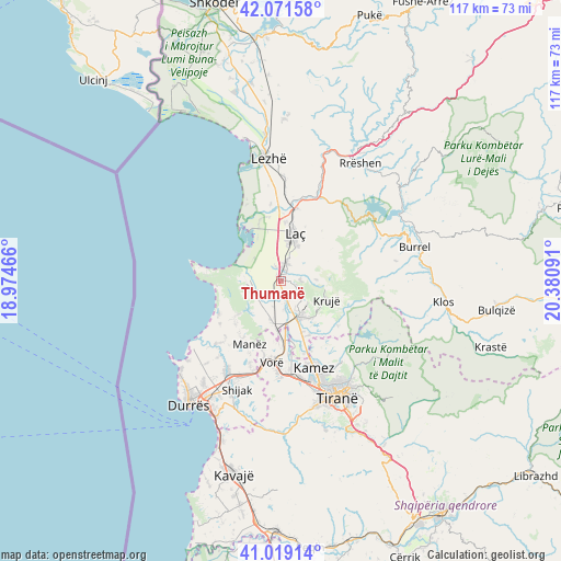
Thumanë GPS coordinates[2]
41° 32' 51" North, 19° 40' 40.008" East
| Map corner | latitude | longitude |
|---|---|---|
| Upper-left | 42.07158°, | 18.97466° |
| Center: | 41.5475°, | 19.67778° |
| Lower-right: | 41.01914°, | 20.38091° |
| Map W x H: | 117×117 km | = 72.7×72.7mi |
| max Lat: | 42.45139° ⇑26.5% North |
| Thumanë: | 41.5475° |
| min Lat: | ⇓73.5% South 39.65889° |
| min Long | Thumanë | max Long |
| 19.40556° | 19.67778° | 20.99° |
| W 20.6%⇐ | ⇒79.4% E |
Elevation
Elevation of Thumanë is 14 m = 46 ft, and this is 360.6 m = 1183 ft below average elevation for this country.
| Max E: |
1352 m = 4436 ft | 91.3% |
| Avg. | 374.6 m = 1229 ft | |
| Thumanë | 14 m = 46 ft | |
Min E: |
-2 m = -7 ft | 8.7% |
See also: Albania elevation on elevation.city.
Geographical zone
Thumanë is located in North temperate zone (between Tropic of Cancer and the Arctic Circle). Distance of this Northern Tropic circle is 2013.7 km =1251.3 mi to South.| Distance of | km | miles | from Thumanë |
|---|---|---|---|
| North Pole | 5387.4 | 3347.6 | to North |
| Arctic Circle | 2781.5 | 1728.3 | to North |
| Tropic Cancer | 2013.7 | 1251.3 | to South |
| Equator | 4619.6 | 2870.5 | to South |


Nearby cities:
15 places around Thumanë: (largest is in red/bold)
• Bubq
8.4 km =5.2 mi,  194°
194°
• Cudhi Zall
14.6 km =9.1 mi,  106°
106°
• Fushë-Krujë
8.4 km =5.2 mi,  156°
156°
• Fushëkuqe
12.4 km =7.7 mi,  337°
337°
• Hasan
7.4 km =4.6 mi,  165°
165°
• Ishëm
6.5 km =4 mi,  267°
267°
• Krujë
10.5 km =6.5 mi, 113°
• Laç
10.2 km =6.3 mi,  16°
16°
• Mamurras
3.5 km =2.2 mi, 19°
• Manzë
15 km =9.3 mi,  208°
208°
• Milot
15.5 km =9.6 mi,  11°
11°
• Nikël
12.9 km =8 mi,  152°
152°
• Prezë
13.4 km =8.3 mi,  181°
181°
• Selitë
11.7 km =7.3 mi,  33°
33°
• Shënkoll
16.1 km =10 mi,  352°
352°
Sources, notices
• [Note1] Compared only with cities in Albania existing in our database
• [Src1] Map data: © OpenStreetMap contributors (CC-BY-SA)
• [Src2] Other city data from geonames.org with taken over terms of usage.
• [Src3] Geographical zone / Annual Mean Temperature by Robert A. Rohde @ Wikipedia
