Krujë geodata
Krujë (Durrës) is a seat of a second-order administrative division; located in Albania in Europe/Tirane (GMT+2) time zone. With population of 21,286 people, there are 16 cities with bigger population in this country. Compared to other cities in Albania, 71.5% of cities are located further ↓South; 66.2% of cities are located further →East and 67% of cities have lower elevation than Krujë. Note1


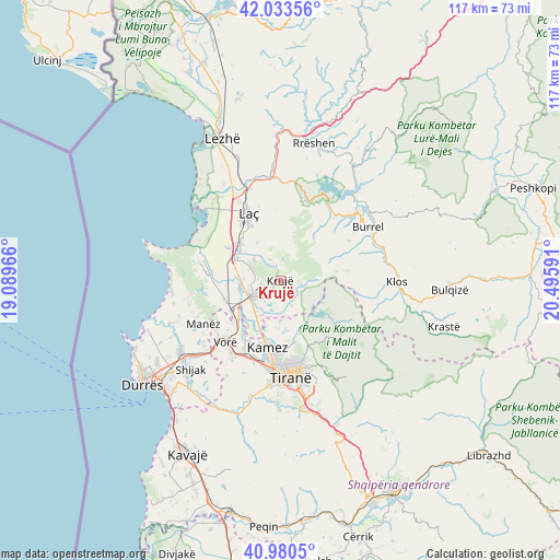
Krujë GPS coordinates[2]
41° 30' 33.012" North, 19° 47' 34.008" East
| Map corner | latitude | longitude |
|---|---|---|
| Upper-left | 42.03356°, | 19.08966° |
| Center: | 41.50917°, | 19.79278° |
| Lower-right: | 40.9805°, | 20.49591° |
| Map W x H: | 117.1×117.1 km | = 72.8×72.8mi |
| max Lat: | 42.45139° ⇑28.5% North |
| Krujë: | 41.50917° |
| min Lat: | ⇓71.5% South 39.65889° |
| min Long | Krujë | max Long |
| 19.40556° | 19.79278° | 20.99° |
| W 33.8%⇐ | ⇒66.2% E |
Elevation
Elevation of Krujë is 509 m = 1670 ft, and this is 134.4 m = 441 ft above average elevation for this country.
| Max E: |
1352 m = 4436 ft | 33% |
| Krujë | 509 m 1670 ft | |
| Avg. | 374.6 m = 1229 ft | |
Min E: |
-2 m = -7 ft | 67% |
See also: Albania elevation on elevation.city.
Geographical zone
Krujë is located in North temperate zone (between Tropic of Cancer and the Arctic Circle). Distance of this Northern Tropic circle is 2009.5 km =1248.6 mi to South.| Distance of | km | miles | from Krujë |
|---|---|---|---|
| North Pole | 5391.7 | 3350.2 | to North |
| Arctic Circle | 2785.8 | 1731 | to North |
| Tropic Cancer | 2009.5 | 1248.6 | to South |
| Equator | 4615.4 | 2867.9 | to South |


Nearby cities:
15 places around Krujë: (largest is in red/bold)
• Bubq
12.4 km =7.7 mi,  251°
251°
• Cudhi Zall
4.4 km =2.7 mi,  89°
89°
• Dajt
16.4 km =10.2 mi,  141°
141°
• Fushë-Krujë
7.1 km =4.4 mi,  241°
241°
• Hasan
8.3 km =5.2 mi, 249°
• Kallmet
10.4 km =6.5 mi,  166°
166°
• Kamëz
14.4 km =8.9 mi,  190°
190°
• Laç
15.5 km =9.6 mi,  334°
334°
• Mamurras
11.3 km =7 mi,  312°
312°
• Nikël
8.1 km =5 mi,  207°
207°
• Prezë
13.5 km =8.4 mi,  227°
227°
• Selitë
14.4 km =8.9 mi,  347°
347°
• Thumanë
10.5 km =6.5 mi,  293°
293°
• Zall-Bastar
14.5 km =9 mi,  127°
127°
• Zall-Herr
13.6 km =8.5 mi, 167°
Sources, notices
• [Note1] Compared only with cities in Albania existing in our database
• [Src1] Map data: © OpenStreetMap contributors (CC-BY-SA)
• [Src2] Other city data from geonames.org with taken over terms of usage.
• [Src3] Geographical zone / Annual Mean Temperature by Robert A. Rohde @ Wikipedia
