Vagharshapat geodata
Vagharshapat (Armavir) is a populated place; located in Armenia in Asia/Yerevan (GMT+4) time zone. With population of 46,540 people, there are 3 cities with bigger population in this country. Compared to other cities in Armenia, 55.7% of cities are located further ↑North; 71.7% of cities are located further →East and 70.7% of cities have higher elevation than Vagharshapat. Note1


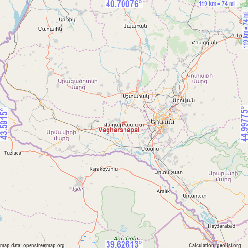
Vagharshapat GPS coordinates[2]
40° 9' 56.052" North, 44° 17' 40.632" East
| Map corner | latitude | longitude |
|---|---|---|
| Upper-left | 40.70076°, | 43.5915° |
| Center: | 40.16557°, | 44.29462° |
| Lower-right: | 39.62613°, | 44.99775° |
| Map W x H: | 119.5×119.5 km | = 74.3×74.3mi |
| max Lat: | 41.24358° ⇑55.7% North |
| Vagharshapat: | 40.16557° |
| min Lat: | ⇓44.3% South 38.90292° |
| min Long | Vagharshapat | max Long |
| 43.74722° | 44.29462° | 46.5446° |
| W 28.3%⇐ | ⇒71.7% E |
Elevation
Elevation of Vagharshapat is 877 m = 2877 ft, and this is 424.5 m = 1393 ft below average elevation for this country.
| Max E: |
2169 m = 7116 ft | 70.7% |
| Avg. | 1301.5 m = 4270 ft | |
| Vagharshapat | 877 m = 2877 ft | |
Min E: |
440 m = 1444 ft | 29.3% |
See also: Vagharshapat elevation on elevation.city.
Geographical zone
Vagharshapat is located in North temperate zone (between Tropic of Cancer and the Arctic Circle). Distance of this Northern Tropic circle is 1860.1 km =1155.8 mi to South.| Distance of | km | miles | from Vagharshapat |
|---|---|---|---|
| North Pole | 5541.1 | 3443.1 | to North |
| Arctic Circle | 2935.2 | 1823.8 | to North |
| Tropic Cancer | 1860.1 | 1155.8 | to South |
| Equator | 4466 | 2775 | to South |


Nearby cities:
15 places around Vagharshapat: (largest is in red/bold)
• Arevashat
7.2 km =4.5 mi,  108°
108°
• Arshaluys
6.9 km =4.3 mi,  273°
273°
• Artimet
2.9 km =1.8 mi,  234°
234°
• Baghramyan
7.1 km =4.4 mi,  63°
63°
• Doghs
6.6 km =4.1 mi,  343°
343°
• Geghakert
4.9 km =3 mi,  296°
296°
• Griboyedov
6.2 km =3.9 mi,  198°
198°
• Hovtamej
3.6 km =2.2 mi, 302°
• Khoronk’
5.2 km =3.2 mi, 230°
• Musalerr
7.2 km =4.5 mi,  98°
98°
• Norakert
5.9 km =3.7 mi,  53°
53°
• Ptghunk’
5.9 km =3.7 mi,  91°
91°
• Tsaghkunk’
2.5 km =1.6 mi,  311°
311°
• Tsiatsan
3.1 km =1.9 mi,  316°
316°
• Voskehat
4.1 km =2.5 mi,  130°
130°
In other languages:
- In France: Etchmiadzin
- In German: Etschmiadsin
- In Italian: Echmiadzin
- In Russian: Вагаршапат
Sources, notices
• [Note1] Compared only with cities in Armenia existing in our database
• [Src1] Map data: © OpenStreetMap contributors (CC-BY-SA)
• [Src2] Other city data from geonames.org with taken over terms of usage.
• [Src3] Geographical zone / Annual Mean Temperature by Robert A. Rohde @ Wikipedia
