Arshaluys geodata
Arshaluys (Armavir) is a populated place; located in Armenia in Asia/Yerevan (GMT+4) time zone. With population of 3,808 people, there are 71 cities with bigger population in this country. Compared to other cities in Armenia, 55.4% of cities are located further ↑North; 79.6% of cities are located further →East and 73.6% of cities have higher elevation than Arshaluys. Note1


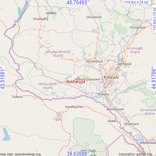
Arshaluys GPS coordinates[2]
40° 10' 10.164" North, 44° 12' 50.148" East
| Map corner | latitude | longitude |
|---|---|---|
| Upper-left | 40.70465°, | 43.51081° |
| Center: | 40.16949°, | 44.21393° |
| Lower-right: | 39.63008°, | 44.91706° |
| Map W x H: | 119.5×119.5 km | = 74.3×74.3mi |
| max Lat: | 41.24358° ⇑55.4% North |
| Arshaluys: | 40.16949° |
| min Lat: | ⇓44.6% South 38.90292° |
| min Long | Arshaluys | max Long |
| 43.74722° | 44.21393° | 46.5446° |
| W 20.4%⇐ | ⇒79.6% E |
Elevation
Elevation of Arshaluys is 868 m = 2848 ft, and this is 433.5 m = 1422 ft below average elevation for this country.
| Max E: |
2169 m = 7116 ft | 73.6% |
| Avg. | 1301.5 m = 4270 ft | |
| Arshaluys | 868 m = 2848 ft | |
Min E: |
440 m = 1444 ft | 26.4% |
See also: Armenia elevation on elevation.city.
Geographical zone
Arshaluys is located in North temperate zone (between Tropic of Cancer and the Arctic Circle). Distance of this Northern Tropic circle is 1860.5 km =1156.1 mi to South.| Distance of | km | miles | from Arshaluys |
|---|---|---|---|
| North Pole | 5540.6 | 3442.8 | to North |
| Arctic Circle | 2934.7 | 1823.5 | to North |
| Tropic Cancer | 1860.5 | 1156.1 | to South |
| Equator | 4466.4 | 2775.3 | to South |


Nearby cities:
15 places around Arshaluys: (largest is in red/bold)
• Aghavnatun
7.8 km =4.8 mi,  25°
25°
• Aknalich
4.7 km =2.9 mi,  238°
238°
• Apaga
8.7 km =5.4 mi,  157°
157°
• Artimet
5 km =3.1 mi,  115°
115°
• Doghs
7.7 km =4.8 mi,  40°
40°
• Geghakert
3 km =1.9 mi,  55°
55°
• Gmbet’
6.9 km =4.3 mi, 29°
• Griboyedov
8 km =5 mi,  141°
141°
• Hovtamej
4.1 km =2.5 mi,  67°
67°
• Khoronk’
4.7 km =2.9 mi, 142°
• Metsamor
8.7 km =5.4 mi,  251°
251°
• Taronik
4.2 km =2.6 mi,  197°
197°
• Tsaghkunk’
5.1 km =3.2 mi,  76°
76°
• Tsiatsan
5.1 km =3.2 mi, 68°
• Vagharshapat
6.9 km =4.3 mi,  93°
93°
Sources, notices
• [Note1] Compared only with cities in Armenia existing in our database
• [Src1] Map data: © OpenStreetMap contributors (CC-BY-SA)
• [Src2] Other city data from geonames.org with taken over terms of usage.
• [Src3] Geographical zone / Annual Mean Temperature by Robert A. Rohde @ Wikipedia
