Griboyedov geodata
Griboyedov (Armavir) is a populated place; located in Armenia in Asia/Yerevan (GMT+4) time zone. With population of 1,879 people, there are 170 cities with bigger population in this country. Compared to other cities in Armenia, 65.9% of cities are located further ↑North; 74.8% of cities are located further →East and 82.8% of cities have higher elevation than Griboyedov. Note1


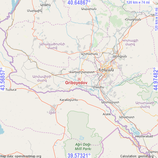
Griboyedov GPS coordinates[2]
40° 6' 47.052" North, 44° 16' 18.084" East
| Map corner | latitude | longitude |
|---|---|---|
| Upper-left | 40.64867°, | 43.56857° |
| Center: | 40.11307°, | 44.27169° |
| Lower-right: | 39.57321°, | 44.97482° |
| Map W x H: | 119.6×119.6 km | = 74.3×74.3mi |
| max Lat: | 41.24358° ⇑65.9% North |
| Griboyedov: | 40.11307° |
| min Lat: | ⇓34.1% South 38.90292° |
| min Long | Griboyedov | max Long |
| 43.74722° | 44.27169° | 46.5446° |
| W 25.2%⇐ | ⇒74.8% E |
Elevation
Elevation of Griboyedov is 845 m = 2772 ft, and this is 456.5 m = 1498 ft below average elevation for this country.
| Max E: |
2169 m = 7116 ft | 82.8% |
| Avg. | 1301.5 m = 4270 ft | |
| Griboyedov | 845 m = 2772 ft | |
Min E: |
440 m = 1444 ft | 17.2% |
See also: Armenia elevation on elevation.city.
Geographical zone
Griboyedov is located in North temperate zone (between Tropic of Cancer and the Arctic Circle). Distance of this Northern Tropic circle is 1854.2 km =1152.1 mi to South.| Distance of | km | miles | from Griboyedov |
|---|---|---|---|
| North Pole | 5546.9 | 3446.7 | to North |
| Arctic Circle | 2941 | 1827.5 | to North |
| Tropic Cancer | 1854.2 | 1152.1 | to South |
| Equator | 4460.2 | 2771.4 | to South |


Nearby cities:
15 places around Griboyedov: (largest is in red/bold)
• Aknashen
2.3 km =1.4 mi,  147°
147°
• Apaga
2.4 km =1.5 mi,  222°
222°
• Arak’s
6.9 km =4.3 mi,  157°
157°
• Artimet
4.1 km =2.5 mi,  354°
354°
• Gay
4.3 km =2.7 mi,  138°
138°
• Haykashen
5.5 km =3.4 mi, 145°
• Hovtamej
7.9 km =4.9 mi, 351°
• Hovtashat
6.4 km =4 mi,  105°
105°
• Khoronk’
3.3 km =2.1 mi,  321°
321°
• Metsamor
4.8 km =3 mi, 159°
• Taronik
6.5 km =4 mi,  290°
290°
• Tsaghkunk’
7.5 km =4.7 mi,  0°
0°
• Vagharshapat
6.2 km =3.9 mi,  18°
18°
• Voskehat
5.9 km =3.7 mi,  57°
57°
• Yeraskhahun
6.3 km =3.9 mi, 224°
Sources, notices
• [Note1] Compared only with cities in Armenia existing in our database
• [Src1] Map data: © OpenStreetMap contributors (CC-BY-SA)
• [Src2] Other city data from geonames.org with taken over terms of usage.
• [Src3] Geographical zone / Annual Mean Temperature by Robert A. Rohde @ Wikipedia
