Ptghunk’ geodata
Ptghunk’ (Armavir) is a populated place; located in Armenia in Asia/Yerevan (GMT+4) time zone. With population of 1,345 people, there are 243 cities with bigger population in this country. Compared to other cities in Armenia, 56.1% of cities are located further ↑North; 67.2% of cities are located further →East and 73.6% of cities have higher elevation than Ptghunk’. Note1


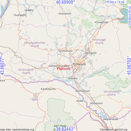
Ptghunk’ GPS coordinates[2]
40° 9' 49.968" North, 44° 21' 50.004" East
| Map corner | latitude | longitude |
|---|---|---|
| Upper-left | 40.69908°, | 43.66077° |
| Center: | 40.16388°, | 44.36389° |
| Lower-right: | 39.62443°, | 45.06702° |
| Map W x H: | 119.5×119.5 km | = 74.3×74.3mi |
| max Lat: | 41.24358° ⇑56.1% North |
| Ptghunk’: | 40.16388° |
| min Lat: | ⇓43.9% South 38.90292° |
| min Long | Ptghunk’ | max Long |
| 43.74722° | 44.36389° | 46.5446° |
| W 32.8%⇐ | ⇒67.2% E |
Elevation
Elevation of Ptghunk’ is 868 m = 2848 ft, and this is 433.5 m = 1422 ft below average elevation for this country.
| Max E: |
2169 m = 7116 ft | 73.6% |
| Avg. | 1301.5 m = 4270 ft | |
| Ptghunk’ | 868 m = 2848 ft | |
Min E: |
440 m = 1444 ft | 26.4% |
See also: Armenia elevation on elevation.city.
Geographical zone
Ptghunk’ is located in North temperate zone (between Tropic of Cancer and the Arctic Circle). Distance of this Northern Tropic circle is 1859.9 km =1155.7 mi to South.| Distance of | km | miles | from Ptghunk’ |
|---|---|---|---|
| North Pole | 5541.3 | 3443.2 | to North |
| Arctic Circle | 2935.4 | 1824 | to North |
| Tropic Cancer | 1859.9 | 1155.7 | to South |
| Equator | 4465.8 | 2774.9 | to South |


Nearby cities:
15 places around Ptghunk’: (largest is in red/bold)
• Arbat’
4.3 km =2.7 mi,  129°
129°
• Arevashat
2.4 km =1.5 mi,  156°
156°
• Argavand
6.5 km =4 mi,  100°
100°
• Aygek
3.4 km =2.1 mi,  34°
34°
• Baghramyan
3.4 km =2.1 mi,  7°
7°
• Dashtavan
7.5 km =4.7 mi, 161°
• Geghanist
6 km =3.7 mi,  109°
109°
• Ghukasavan
6 km =3.7 mi, 131°
• Hayanist
4.8 km =3 mi,  165°
165°
• Hovtashat
7.6 km =4.7 mi,  192°
192°
• Merdzavan
3.7 km =2.3 mi,  57°
57°
• Musalerr
1.5 km =0.9 mi, 127°
• Norakert
3.9 km =2.4 mi,  342°
342°
• Vagharshapat
5.9 km =3.7 mi,  271°
271°
• Voskehat
3.7 km =2.3 mi,  228°
228°
Sources, notices
• [Note1] Compared only with cities in Armenia existing in our database
• [Src1] Map data: © OpenStreetMap contributors (CC-BY-SA)
• [Src2] Other city data from geonames.org with taken over terms of usage.
• [Src3] Geographical zone / Annual Mean Temperature by Robert A. Rohde @ Wikipedia
