Verin Getashen geodata
Verin Getashen (Gegharkunik) is a populated place; located in Armenia in Asia/Yerevan (GMT+4) time zone. With population of 4,173 people, there are 61 cities with bigger population in this country. Compared to other cities in Armenia, 64% of cities are located further ↑North; 84.7% of cities are located further ←West and 94.3% of cities have lower elevation than Verin Getashen. Note1


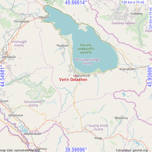
Verin Getashen GPS coordinates[2]
40° 7' 50.448" North, 45° 15' 10.548" East
| Map corner | latitude | longitude |
|---|---|---|
| Upper-left | 40.66614°, | 44.54981° |
| Center: | 40.13068°, | 45.25293° |
| Lower-right: | 39.59096°, | 45.95606° |
| Map W x H: | 119.5×119.5 km | = 74.3×74.3mi |
| max Lat: | 41.24358° ⇑64% North |
| Verin Getashen: | 40.13068° |
| min Lat: | ⇓36% South 38.90292° |
| min Long | Verin Getashen | max Long |
| 43.74722° | 45.25293° | 46.5446° |
| W 84.7%⇐ | ⇒15.3% E |
Elevation
Elevation of Verin Getashen is 1980 m = 6496 ft, and this is 678.5 m = 2226 ft above average elevation for this country.
| Max E: |
2169 m = 7116 ft | 5.7% |
| Verin Getashen | 1980 m 6496 ft | |
| Avg. | 1301.5 m = 4270 ft | |
Min E: |
440 m = 1444 ft | 94.3% |
See also: Armenia elevation on elevation.city.
Geographical zone
Verin Getashen is located in North temperate zone (between Tropic of Cancer and the Arctic Circle). Distance of this Northern Tropic circle is 1856.2 km =1153.4 mi to South.| Distance of | km | miles | from Verin Getashen |
|---|---|---|---|
| North Pole | 5544.9 | 3445.4 | to North |
| Arctic Circle | 2939.1 | 1826.3 | to North |
| Tropic Cancer | 1856.2 | 1153.4 | to South |
| Equator | 4462.1 | 2772.6 | to South |


Nearby cities:
15 places around Verin Getashen: (largest is in red/bold)
• Astghadzor
8.8 km =5.5 mi,  96°
96°
• Dzoragyugh
7.3 km =4.5 mi,  306°
306°
• Karanlukh
4.3 km =2.7 mi,  133°
133°
• Lanjaghbyur
18 km =11.2 mi,  329°
329°
• Lichk’
3.5 km =2.2 mi, 334°
• Madina
6 km =3.7 mi,  178°
178°
• Martuni
4.6 km =2.9 mi,  78°
78°
• Nerk’in Getashen
2 km =1.2 mi,  51°
51°
• Sarukhan
20.7 km =12.9 mi, 329°
• Tsovasar
5.3 km =3.3 mi,  279°
279°
• Tsovinar
18.5 km =11.5 mi, 80°
• Vaghashen
6.6 km =4.1 mi, 84°
• Vardadzor
8.1 km =5 mi,  320°
320°
• Vardenik
16.2 km =10.1 mi,  88°
88°
• Yeranos
9.7 km =6 mi, 327°
Sources, notices
• [Note1] Compared only with cities in Armenia existing in our database
• [Src1] Map data: © OpenStreetMap contributors (CC-BY-SA)
• [Src2] Other city data from geonames.org with taken over terms of usage.
• [Src3] Geographical zone / Annual Mean Temperature by Robert A. Rohde @ Wikipedia
