Vardenik geodata
Vardenik (Gegharkunik) is a populated place; located in Armenia in Asia/Yerevan (GMT+4) time zone. With population of 7,709 people, there are 28 cities with bigger population in this country. Compared to other cities in Armenia, 63.1% of cities are located further ↑North; 91.1% of cities are located further ←West and 93.3% of cities have lower elevation than Vardenik. Note1


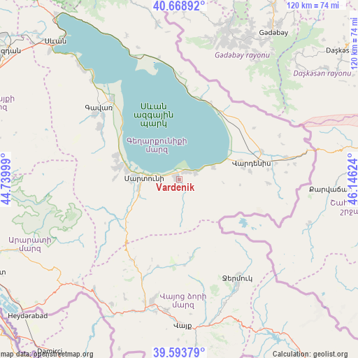
Vardenik GPS coordinates[2]
40° 8' 0.528" North, 45° 26' 35.196" East
| Map corner | latitude | longitude |
|---|---|---|
| Upper-left | 40.66892°, | 44.73999° |
| Center: | 40.13348°, | 45.44311° |
| Lower-right: | 39.59379°, | 46.14624° |
| Map W x H: | 119.5×119.5 km | = 74.3×74.3mi |
| max Lat: | 41.24358° ⇑63.1% North |
| Vardenik: | 40.13348° |
| min Lat: | ⇓36.9% South 38.90292° |
| min Long | Vardenik | max Long |
| 43.74722° | 45.44311° | 46.5446° |
| W 91.1%⇐ | ⇒8.9% E |
Elevation
Elevation of Vardenik is 1971 m = 6467 ft, and this is 669.5 m = 2197 ft above average elevation for this country.
| Max E: |
2169 m = 7116 ft | 6.7% |
| Vardenik | 1971 m 6467 ft | |
| Avg. | 1301.5 m = 4270 ft | |
Min E: |
440 m = 1444 ft | 93.3% |
See also: Armenia elevation on elevation.city.
Geographical zone
Vardenik is located in North temperate zone (between Tropic of Cancer and the Arctic Circle). Distance of this Northern Tropic circle is 1856.5 km =1153.6 mi to South.| Distance of | km | miles | from Vardenik |
|---|---|---|---|
| North Pole | 5544.6 | 3445.3 | to North |
| Arctic Circle | 2938.7 | 1826 | to North |
| Tropic Cancer | 1856.5 | 1153.6 | to South |
| Equator | 4462.4 | 2772.8 | to South |


Nearby cities:
15 places around Vardenik: (largest is in red/bold)
• Astghadzor
7.5 km =4.7 mi,  260°
260°
• Dzoragyugh
22.4 km =13.9 mi,  280°
280°
• Karanlukh
13.4 km =8.3 mi, 256°
• Karchaghbyur
12.2 km =7.6 mi,  70°
70°
• Lichk’
17.9 km =11.1 mi, 279°
• Madina
17.2 km =10.7 mi,  248°
248°
• Martuni
11.7 km =7.3 mi,  272°
272°
• Nerk’in Getashen
14.7 km =9.1 mi, 273°
• Tsovak
17 km =10.6 mi, 71°
• Tsovasar
21.4 km =13.3 mi, 271°
• Tsovinar
3.6 km =2.2 mi,  35°
35°
• Vaghashen
9.6 km =6 mi, 271°
• Vardadzor
22.1 km =13.7 mi,  285°
285°
• Verin Getashen
16.2 km =10.1 mi, 268°
• Yeranos
22.7 km =14.1 mi, 290°
Sources, notices
• [Note1] Compared only with cities in Armenia existing in our database
• [Src1] Map data: © OpenStreetMap contributors (CC-BY-SA)
• [Src2] Other city data from geonames.org with taken over terms of usage.
• [Src3] Geographical zone / Annual Mean Temperature by Robert A. Rohde @ Wikipedia
