Dzoragyugh geodata
Dzoragyugh (Gegharkunik) is a populated place; located in Armenia in Asia/Yerevan (GMT+4) time zone. With population of 3,570 people, there are 74 cities with bigger population in this country. Compared to other cities in Armenia, 55.1% of cities are located further ↑North; 81.8% of cities are located further ←West and 96.5% of cities have lower elevation than Dzoragyugh. Note1


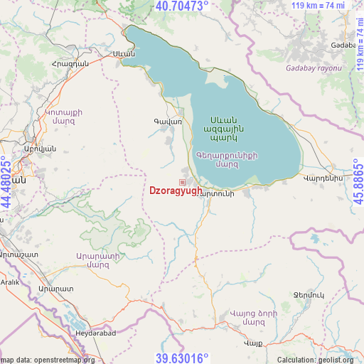
Dzoragyugh GPS coordinates[2]
40° 10' 10.452" North, 45° 11' 0.132" East
| Map corner | latitude | longitude |
|---|---|---|
| Upper-left | 40.70473°, | 44.48025° |
| Center: | 40.16957°, | 45.18337° |
| Lower-right: | 39.63016°, | 45.8865° |
| Map W x H: | 119.5×119.5 km | = 74.3×74.3mi |
| max Lat: | 41.24358° ⇑55.1% North |
| Dzoragyugh: | 40.16957° |
| min Lat: | ⇓44.9% South 38.90292° |
| min Long | Dzoragyugh | max Long |
| 43.74722° | 45.18337° | 46.5446° |
| W 81.8%⇐ | ⇒18.2% E |
Elevation
Elevation of Dzoragyugh is 2016 m = 6614 ft, and this is 714.5 m = 2344 ft above average elevation for this country.
| Max E: |
2169 m = 7116 ft | 3.5% |
| Dzoragyugh | 2016 m 6614 ft | |
| Avg. | 1301.5 m = 4270 ft | |
Min E: |
440 m = 1444 ft | 96.5% |
See also: Armenia elevation on elevation.city.
Geographical zone
Dzoragyugh is located in North temperate zone (between Tropic of Cancer and the Arctic Circle). Distance of this Northern Tropic circle is 1860.5 km =1156.1 mi to South.| Distance of | km | miles | from Dzoragyugh |
|---|---|---|---|
| North Pole | 5540.6 | 3442.8 | to North |
| Arctic Circle | 2934.7 | 1823.5 | to North |
| Tropic Cancer | 1860.5 | 1156.1 | to South |
| Equator | 4466.4 | 2775.3 | to South |


Nearby cities:
15 places around Dzoragyugh: (largest is in red/bold)
• Astghadzor
15.5 km =9.6 mi,  109°
109°
• Gandzak
17.3 km =10.7 mi,  339°
339°
• Gavarr
21.1 km =13.1 mi,  346°
346°
• Karanlukh
11.6 km =7.2 mi,  128°
128°
• Lanjaghbyur
11.6 km =7.2 mi, 343°
• Lichk’
4.5 km =2.8 mi,  104°
104°
• Madina
12 km =7.5 mi,  149°
149°
• Martuni
10.9 km =6.8 mi, 108°
• Nerk’in Getashen
8.1 km =5 mi, 112°
• Sarukhan
14.3 km =8.9 mi, 341°
• Tsovasar
3.5 km =2.2 mi,  169°
169°
• Vaghashen
13.1 km =8.1 mi, 106°
• Vardadzor
2.1 km =1.3 mi,  20°
20°
• Verin Getashen
7.3 km =4.5 mi, 126°
• Yeranos
3.9 km =2.4 mi,  10°
10°
Sources, notices
• [Note1] Compared only with cities in Armenia existing in our database
• [Src1] Map data: © OpenStreetMap contributors (CC-BY-SA)
• [Src2] Other city data from geonames.org with taken over terms of usage.
• [Src3] Geographical zone / Annual Mean Temperature by Robert A. Rohde @ Wikipedia
