Maralik geodata
Maralik (Shirak) is a populated place; located in Armenia in Asia/Yerevan (GMT+4) time zone. With population of 4,959 people, there are 43 cities with bigger population in this country. Compared to other cities in Armenia, 72.6% of cities are located further ↓South; 96.5% of cities are located further →East and 76.4% of cities have lower elevation than Maralik. Note1


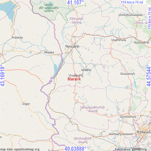
Maralik GPS coordinates[2]
40° 34' 30.252" North, 43° 52' 20.316" East
| Map corner | latitude | longitude |
|---|---|---|
| Upper-left | 41.107°, | 43.16919° |
| Center: | 40.57507°, | 43.87231° |
| Lower-right: | 40.03888°, | 44.57544° |
| Map W x H: | 118.8×118.8 km | = 73.8×73.8mi |
| max Lat: | 41.24358° ⇑27.4% North |
| Maralik: | 40.57507° |
| min Lat: | ⇓72.6% South 38.90292° |
| min Long | Maralik | max Long |
| 43.74722° | 43.87231° | 46.5446° |
| W 3.5%⇐ | ⇒96.5% E |
Elevation
Elevation of Maralik is 1713 m = 5620 ft, and this is 411.5 m = 1350 ft above average elevation for this country.
| Max E: |
2169 m = 7116 ft | 23.6% |
| Maralik | 1713 m 5620 ft | |
| Avg. | 1301.5 m = 4270 ft | |
Min E: |
440 m = 1444 ft | 76.4% |
See also: Armenia elevation on elevation.city.
Geographical zone
Maralik is located in North temperate zone (between Tropic of Cancer and the Arctic Circle). Distance of this Northern Tropic circle is 1905.6 km =1184.1 mi to South.| Distance of | km | miles | from Maralik |
|---|---|---|---|
| North Pole | 5495.5 | 3414.7 | to North |
| Arctic Circle | 2889.6 | 1795.5 | to North |
| Tropic Cancer | 1905.6 | 1184.1 | to South |
| Equator | 4511.5 | 2803.3 | to South |


Nearby cities:
15 places around Maralik: (largest is in red/bold)
• Anushavan
12.4 km =7.7 mi,  47°
47°
• Arevik
18.7 km =11.6 mi,  8°
8°
• Arevshat
16.9 km =10.5 mi,  59°
59°
• Azatan
16.5 km =10.3 mi,  346°
346°
• Dzit’hank’ov
8.6 km =5.3 mi,  210°
210°
• Horrom
9.5 km =5.9 mi, 9°
• Lerrnakert
5.8 km =3.6 mi,  103°
103°
• Meghrashen
13 km =8.1 mi,  33°
33°
• Mets Mant’ash
17.3 km =10.7 mi, 63°
• Pemzashen
6.1 km =3.8 mi,  78°
78°
• P’ok’r Mant’ash
16.4 km =10.2 mi, 63°
• Saratak
10.7 km =6.6 mi,  0°
0°
• Spandaryan
15.4 km =9.6 mi, 51°
• T’alin
20.4 km =12.7 mi,  178°
178°
• Yerazgavors
17 km =10.6 mi,  321°
321°
Sources, notices
• [Note1] Compared only with cities in Armenia existing in our database
• [Src1] Map data: © OpenStreetMap contributors (CC-BY-SA)
• [Src2] Other city data from geonames.org with taken over terms of usage.
• [Src3] Geographical zone / Annual Mean Temperature by Robert A. Rohde @ Wikipedia
