Aknalich geodata
Aknalich (Armavir) is a populated place; located in Armenia in Asia/Yerevan (GMT+4) time zone. With population of 2,654 people, there are 109 cities with bigger population in this country. Compared to other cities in Armenia, 58.9% of cities are located further ↑North; 81.5% of cities are located further →East and 75.8% of cities have higher elevation than Aknalich. Note1


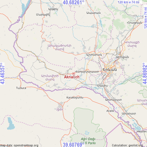
Aknalich GPS coordinates[2]
40° 8' 50.208" North, 44° 10' 0.084" East
| Map corner | latitude | longitude |
|---|---|---|
| Upper-left | 40.68261°, | 43.46357° |
| Center: | 40.14728°, | 44.16669° |
| Lower-right: | 39.60769°, | 44.86982° |
| Map W x H: | 119.5×119.5 km | = 74.3×74.3mi |
| max Lat: | 41.24358° ⇑58.9% North |
| Aknalich: | 40.14728° |
| min Lat: | ⇓41.1% South 38.90292° |
| min Long | Aknalich | max Long |
| 43.74722° | 44.16669° | 46.5446° |
| W 18.5%⇐ | ⇒81.5% E |
Elevation
Elevation of Aknalich is 862 m = 2828 ft, and this is 439.5 m = 1442 ft below average elevation for this country.
| Max E: |
2169 m = 7116 ft | 75.8% |
| Avg. | 1301.5 m = 4270 ft | |
| Aknalich | 862 m = 2828 ft | |
Min E: |
440 m = 1444 ft | 24.2% |
See also: Armenia elevation on elevation.city.
Geographical zone
Aknalich is located in North temperate zone (between Tropic of Cancer and the Arctic Circle). Distance of this Northern Tropic circle is 1858 km =1154.5 mi to South.| Distance of | km | miles | from Aknalich |
|---|---|---|---|
| North Pole | 5543.1 | 3444.3 | to North |
| Arctic Circle | 2937.2 | 1825.1 | to North |
| Tropic Cancer | 1858 | 1154.5 | to South |
| Equator | 4464 | 2773.8 | to South |


Nearby cities:
15 places around Aknalich: (largest is in red/bold)
• Apaga
9.2 km =5.7 mi,  127°
127°
• Arevik
8.1 km =5 mi,  229°
229°
• Arshaluys
4.7 km =2.9 mi,  58°
58°
• Artimet
8.5 km =5.3 mi,  87°
87°
• Geghakert
7.8 km =4.8 mi, 57°
• Hovtamej
8.8 km =5.5 mi, 62°
• Khoronk’
7 km =4.3 mi,  100°
100°
• Mayisyan
6.4 km =4 mi,  279°
279°
• Metsamor
4.3 km =2.7 mi,  265°
265°
• Mrgashat
7.5 km =4.7 mi,  255°
255°
• Taronik
3.2 km =2 mi,  118°
118°
• Tsaghkunk’
9.7 km =6 mi,  67°
67°
• Tsiatsan
9.7 km =6 mi, 63°
• Yeghegnut
6.5 km =4 mi,  180°
180°
• Yeraskhahun
9.5 km =5.9 mi,  151°
151°
Sources, notices
• [Note1] Compared only with cities in Armenia existing in our database
• [Src1] Map data: © OpenStreetMap contributors (CC-BY-SA)
• [Src2] Other city data from geonames.org with taken over terms of usage.
• [Src3] Geographical zone / Annual Mean Temperature by Robert A. Rohde @ Wikipedia
