Taronik geodata
Taronik (Armavir) is a populated place; located in Armenia in Asia/Yerevan (GMT+4) time zone. With population of 1,874 people, there are 172 cities with bigger population in this country. Compared to other cities in Armenia, 62.7% of cities are located further ↑North; 79.9% of cities are located further →East and 80.6% of cities have higher elevation than Taronik. Note1


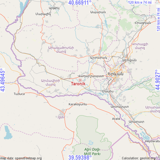
Taronik GPS coordinates[2]
40° 8' 1.212" North, 44° 11' 58.452" East
| Map corner | latitude | longitude |
|---|---|---|
| Upper-left | 40.66911°, | 43.49645° |
| Center: | 40.13367°, | 44.19957° |
| Lower-right: | 39.59398°, | 44.9027° |
| Map W x H: | 119.5×119.5 km | = 74.3×74.3mi |
| max Lat: | 41.24358° ⇑62.7% North |
| Taronik: | 40.13367° |
| min Lat: | ⇓37.3% South 38.90292° |
| min Long | Taronik | max Long |
| 43.74722° | 44.19957° | 46.5446° |
| W 20.1%⇐ | ⇒79.9% E |
Elevation
Elevation of Taronik is 851 m = 2792 ft, and this is 450.5 m = 1478 ft below average elevation for this country.
| Max E: |
2169 m = 7116 ft | 80.6% |
| Avg. | 1301.5 m = 4270 ft | |
| Taronik | 851 m = 2792 ft | |
Min E: |
440 m = 1444 ft | 19.4% |
See also: Armenia elevation on elevation.city.
Geographical zone
Taronik is located in North temperate zone (between Tropic of Cancer and the Arctic Circle). Distance of this Northern Tropic circle is 1856.5 km =1153.6 mi to South.| Distance of | km | miles | from Taronik |
|---|---|---|---|
| North Pole | 5544.6 | 3445.3 | to North |
| Arctic Circle | 2938.7 | 1826 | to North |
| Tropic Cancer | 1856.5 | 1153.6 | to South |
| Equator | 4462.4 | 2772.8 | to South |


Nearby cities:
15 places around Taronik: (largest is in red/bold)
• Aknalich
3.2 km =2 mi,  298°
298°
• Aknashen
8.5 km =5.3 mi,  119°
119°
• Apaga
6.1 km =3.8 mi,  131°
131°
• Arshaluys
4.2 km =2.6 mi,  17°
17°
• Artimet
6 km =3.7 mi,  72°
72°
• Geghakert
6.8 km =4.2 mi,  32°
32°
• Griboyedov
6.5 km =4 mi,  110°
110°
• Hovtamej
7.4 km =4.6 mi,  42°
42°
• Khoronk’
4.1 km =2.5 mi,  86°
86°
• Metsamor
7.1 km =4.4 mi,  279°
279°
• Tsaghkunk’
8.1 km =5 mi,  49°
49°
• Tsiatsan
8.3 km =5.2 mi, 45°
• Vagharshapat
8.8 km =5.5 mi, 66°
• Yeghegnut
5.7 km =3.5 mi,  209°
209°
• Yeraskhahun
7 km =4.3 mi,  166°
166°
Sources, notices
• [Note1] Compared only with cities in Armenia existing in our database
• [Src1] Map data: © OpenStreetMap contributors (CC-BY-SA)
• [Src2] Other city data from geonames.org with taken over terms of usage.
• [Src3] Geographical zone / Annual Mean Temperature by Robert A. Rohde @ Wikipedia
