Cabinda geodata
Cabinda is a seat of a first-order administrative division; located in Angola in Africa/Luanda (GMT+1) time zone. With population of 66,020 people, there are 10 cities with bigger population in this country. Compared to other cities in Angola, 100% of cities are located further ↓South; 97.2% of cities are located further →East and 100% of cities have higher elevation than Cabinda. Note1


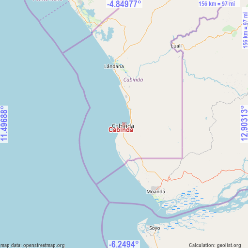
Cabinda GPS coordinates[2]
5° 33' 0" South, 12° 12' 0" East
| Map corner | latitude | longitude |
|---|---|---|
| Upper-left | -4.84977°, | 11.49688° |
| Center: | -5.55°, | 12.2° |
| Lower-right: | -6.2494°, | 12.90313° |
| Map W x H: | 155.6×155.6 km | = 96.7×96.7mi |
| max Lat: | -5.55° ⇑0% North |
| Cabinda: | -5.55° |
| min Lat: | ⇓100% South -17.06667° |
| min Long | Cabinda | max Long |
| 12.15222° | 12.2° | 22.22466° |
| W 2.8%⇐ | ⇒97.2% E |
Elevation
Elevation of Cabinda is 1 m = 3 ft, and this is 967.9 m = 3176 ft below average elevation for this country.
| Max E: |
1895 m = 6217 ft | 100% |
| Avg. | 968.9 m = 3179 ft | |
| Cabinda | 1 m = 3 ft | |
Min E: |
1 m = 3 ft | 0% |
See also: Cabinda elevation on elevation.city.
Geographical zone
Cabinda is located in South Torrid zone (between Equator and Tropic of Capricorn). Distance of Equator is 617.1 km =383.4 mi to North.| Distance of | km | miles | from Cabinda |
|---|---|---|---|
| Equator | 617.1 | 383.4 | to North |
| Tropic Capricorn | 1988.8 | 1235.8 | to South |
| Antarctic Circle | 6784.1 | 4215.4 | to South |
| South Pole | 9390 | 5834.7 | to South |


Nearby cities:
6 places around Cabinda: (largest is in red/bold)
• Caxito
373.5 km =232.1 mi,  154°
154°
• Luanda
382.9 km =237.9 mi,  162°
162°
• Mbanza Congo
239.3 km =148.7 mi,  109°
109°
• N'zeto
200.9 km =124.8 mi, 158°
• Soio
67.7 km =42.1 mi, 163°
• Uíge
390.2 km =242.5 mi,  125°
125°
Sources, notices
• [Note1] Compared only with cities in Angola existing in our database
• [Src1] Map data: © OpenStreetMap contributors (CC-BY-SA)
• [Src2] Other city data from geonames.org with taken over terms of usage.
• [Src3] Geographical zone / Annual Mean Temperature by Robert A. Rohde @ Wikipedia
