Uíge geodata
Uíge is a seat of a first-order administrative division; located in Angola in Africa/Luanda (GMT+1) time zone. With population of 60,008 people, there are 11 cities with bigger population in this country. Compared to other cities in Angola, 88.9% of cities are located further ↓South; 58.3% of cities are located further →East and 66.7% of cities have higher elevation than Uíge. Note1


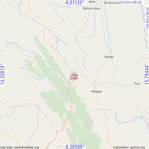
Uíge GPS coordinates[2]
7° 36' 31.464" South, 15° 3' 40.716" East
| Map corner | latitude | longitude |
|---|---|---|
| Upper-left | -6.91126°, | 14.35819° |
| Center: | -7.60874°, | 15.06131° |
| Lower-right: | -8.30509°, | 15.76444° |
| Map W x H: | 155×155 km | = 96.3×96.3mi |
| max Lat: | -5.55° ⇑11.1% North |
| Uíge: | -7.60874° |
| min Lat: | ⇓88.9% South -17.06667° |
| min Long | Uíge | max Long |
| 12.15222° | 15.06131° | 22.22466° |
| W 41.7%⇐ | ⇒58.3% E |
Elevation
Elevation of Uíge is 825 m = 2707 ft, and this is 143.9 m = 472 ft below average elevation for this country.
| Max E: |
1895 m = 6217 ft | 66.7% |
| Avg. | 968.9 m = 3179 ft | |
| Uíge | 825 m = 2707 ft | |
Min E: |
1 m = 3 ft | 33.3% |
See also: Uíge elevation on elevation.city.
Geographical zone
Uíge is located in South Torrid zone (between Equator and Tropic of Capricorn). Distance of Equator is 846 km =525.7 mi to North.| Distance of | km | miles | from Uíge |
|---|---|---|---|
| Equator | 846 | 525.7 | to North |
| Tropic Capricorn | 1759.9 | 1093.6 | to South |
| Antarctic Circle | 6555.2 | 4073.2 | to South |
| South Pole | 9161 | 5692.4 | to South |


Nearby cities:
12 places around Uíge: (largest is in red/bold)
• Cabinda
390.2 km =242.5 mi,  305°
305°
• Camabatela
73.1 km =45.4 mi,  151°
151°
• Caxito
187.8 km =116.7 mi,  234°
234°
• Luanda
243 km =151 mi,  235°
235°
• Malanje
256.7 km =159.5 mi, 146°
• Mbanza Congo
174.6 km =108.5 mi,  328°
328°
• N'zeto
245.6 km =152.6 mi,  279°
279°
• N’dalatando
188.5 km =117.1 mi,  185°
185°
• Quibala
347.6 km =216 mi,  181°
181°
• Soio
339.4 km =210.9 mi,  298°
298°
• Sumbe
421.7 km =262 mi,  198°
198°
• Uacu Cungo
416.8 km =259 mi, 179°
Sources, notices
• [Note1] Compared only with cities in Angola existing in our database
• [Src1] Map data: © OpenStreetMap contributors (CC-BY-SA)
• [Src2] Other city data from geonames.org with taken over terms of usage.
• [Src3] Geographical zone / Annual Mean Temperature by Robert A. Rohde @ Wikipedia
