Caxito geodata
Caxito (Bengo) is a seat of a first-order administrative division; located in Angola in Africa/Luanda (GMT+1) time zone. With population of 28,224 people, there are 15 cities with bigger population in this country. Compared to other cities in Angola, 80.6% of cities are located further ↓South; 75% of cities are located further →East and 77.8% of cities have higher elevation than Caxito. Note1


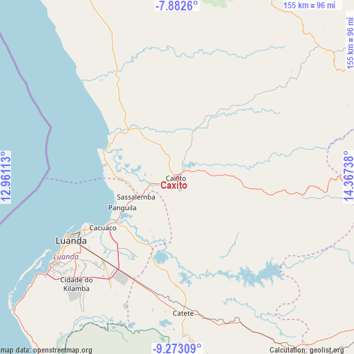
Caxito GPS coordinates[2]
8° 34' 42.528" South, 13° 39' 51.3" East
| Map corner | latitude | longitude |
|---|---|---|
| Upper-left | -7.8826°, | 12.96113° |
| Center: | -8.57848°, | 13.66425° |
| Lower-right: | -9.27309°, | 14.36738° |
| Map W x H: | 154.6×154.6 km | = 96.1×96.1mi |
| max Lat: | -5.55° ⇑19.4% North |
| Caxito: | -8.57848° |
| min Lat: | ⇓80.6% South -17.06667° |
| min Long | Caxito | max Long |
| 12.15222° | 13.66425° | 22.22466° |
| W 25%⇐ | ⇒75% E |
Elevation
Elevation of Caxito is 20 m = 66 ft, and this is 948.9 m = 3113 ft below average elevation for this country.
| Max E: |
1895 m = 6217 ft | 77.8% |
| Avg. | 968.9 m = 3179 ft | |
| Caxito | 20 m = 66 ft | |
Min E: |
1 m = 3 ft | 22.2% |
See also: Angola elevation on elevation.city.
Geographical zone
Caxito is located in South Torrid zone (between Equator and Tropic of Capricorn). Distance of Equator is 953.8 km =592.7 mi to North.| Distance of | km | miles | from Caxito |
|---|---|---|---|
| Equator | 953.8 | 592.7 | to North |
| Tropic Capricorn | 1652.1 | 1026.6 | to South |
| Antarctic Circle | 6447.3 | 4006.2 | to South |
| South Pole | 9053.2 | 5625.4 | to South |


Nearby cities:
14 places around Caxito: (largest is in red/bold)
• Cabinda
373.5 km =232.1 mi,  334°
334°
• Camabatela
193.1 km =120 mi,  77°
77°
• Catumbela
428.4 km =266.2 mi,  181°
181°
• Lobito
421.2 km =261.7 mi, 181°
• Luanda
55.3 km =34.4 mi,  238°
238°
• Malanje
312.8 km =194.4 mi,  109°
109°
• Mbanza Congo
264.7 km =164.5 mi,  13°
13°
• N'zeto
173.7 km =107.9 mi, 329°
• N’dalatando
158.6 km =98.5 mi,  120°
120°
• Quibala
279.7 km =173.8 mi,  148°
148°
• Soio
307 km =190.8 mi, 332°
• Sumbe
292.8 km =181.9 mi, 176°
• Uacu Cungo
347.5 km =215.9 mi, 152°
• Uíge
187.8 km =116.7 mi,  54°
54°
Sources, notices
• [Note1] Compared only with cities in Angola existing in our database
• [Src1] Map data: © OpenStreetMap contributors (CC-BY-SA)
• [Src2] Other city data from geonames.org with taken over terms of usage.
• [Src3] Geographical zone / Annual Mean Temperature by Robert A. Rohde @ Wikipedia
