Cerro Corá geodata
Cerro Corá (Misiones) is a populated place; located in Argentina in America/Argentina/Cordoba (GMT-3) time zone. With population of 1,153 people, there are 744 cities with bigger population in this country. Compared to other cities in Argentina, 80.2% of cities are located further ↓South; 94.8% of cities are located further ←West and 52.4% of cities have lower elevation than Cerro Corá. Note1


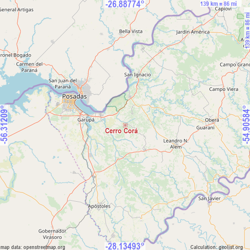
Cerro Corá GPS coordinates[2]
27° 30' 47.16" South, 55° 36' 32.256" West
| Map corner | latitude | longitude |
|---|---|---|
| Upper-left | -26.88774°, | -56.31209° |
| Center: | -27.5131°, | -55.60896° |
| Lower-right: | -28.13493°, | -54.90584° |
| Map W x H: | 138.7×138.7 km | = 86.2×86.2mi |
| max Lat: | -21.94467° ⇑19.8% North |
| Cerro Corá: | -27.5131° |
| min Lat: | ⇓80.2% South -54.81084° |
| min Long | Cerro Corá | max Long |
| -72.88605° | -55.60896° | -53.64581° |
| W 94.8%⇐ | ⇒5.2% E |
Elevation
Elevation of Cerro Corá is 161 m = 528 ft, and this is 188.3 m = 618 ft below average elevation for this country.
| Max E: |
4040 m = 13255 ft | 47.6% |
| Avg. | 349.3 m = 1146 ft | |
| Cerro Corá | 161 m = 528 ft | |
Min E: |
-2 m = -7 ft | 52.4% |
See also: Argentina elevation on elevation.city.
Geographical zone
Cerro Corá is located in South temperate zone (between Tropic of Capricorn and the Antarctic Circle). Distance of this Southern Tropic circle is 453.3 km =281.7 mi to North.| Distance of | km | miles | from Cerro Corá |
|---|---|---|---|
| Equator | 3059.2 | 1900.9 | to North |
| Tropic Capricorn | 453.3 | 281.7 | to North |
| Antarctic Circle | 4342 | 2698 | to South |
| South Pole | 6947.9 | 4317.2 | to South |


Nearby cities:
15 places around Cerro Corá: (largest is in red/bold)
• Almafuerte
20.4 km =12.7 mi,  88°
88°
• Arroyo del Medio
28.8 km =17.9 mi,  135°
135°
• Bonpland
13.4 km =8.3 mi,  75°
75°
• Candelaria
14.7 km =9.1 mi,  293°
293°
• Cerro Azul
17.4 km =10.8 mi, 140°
• Garupá
22 km =13.7 mi,  279°
279°
• Gobernador Roca
39 km =24.2 mi,  21°
21°
• Leandro N. Alem
29.7 km =18.5 mi,  109°
109°
• Loreto
21.8 km =13.5 mi, 22°
• Mártires
25 km =15.5 mi,  66°
66°
• Posadas
32.7 km =20.3 mi,  299°
299°
• San Carlos
38.4 km =23.9 mi,  227°
227°
• San Ignacio
29.5 km =18.3 mi,  14°
14°
• San José
33.3 km =20.7 mi,  210°
210°
• Santa Ana
16.4 km =10.2 mi, 9°
Sources, notices
• [Note1] Compared only with cities in Argentina existing in our database
• [Src1] Map data: © OpenStreetMap contributors (CC-BY-SA)
• [Src2] Other city data from geonames.org with taken over terms of usage.
• [Src3] Geographical zone / Annual Mean Temperature by Robert A. Rohde @ Wikipedia
