Bonpland geodata
Bonpland (Misiones) is a populated place; located in Argentina in America/Argentina/Cordoba (GMT-3) time zone. With population of 2,173 people, there are 623 cities with bigger population in this country. Compared to other cities in Argentina, 80.9% of cities are located further ↓South; 95.5% of cities are located further ←West and 57.3% of cities have lower elevation than Bonpland. Note1


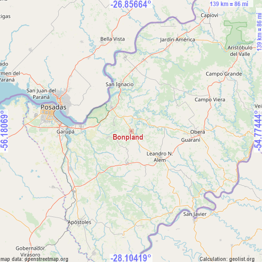
Bonpland GPS coordinates[2]
27° 28' 55.848" South, 55° 28' 39.216" West
| Map corner | latitude | longitude |
|---|---|---|
| Upper-left | -26.85664°, | -56.18069° |
| Center: | -27.48218°, | -55.47756° |
| Lower-right: | -28.10419°, | -54.77444° |
| Map W x H: | 138.7×138.7 km | = 86.2×86.2mi |
| max Lat: | -21.94467° ⇑19.1% North |
| Bonpland: | -27.48218° |
| min Lat: | ⇓80.9% South -54.81084° |
| min Long | Bonpland | max Long |
| -72.88605° | -55.47756° | -53.64581° |
| W 95.5%⇐ | ⇒4.5% E |
Elevation
Elevation of Bonpland is 187 m = 614 ft, and this is 162.3 m = 532 ft below average elevation for this country.
| Max E: |
4040 m = 13255 ft | 42.7% |
| Avg. | 349.3 m = 1146 ft | |
| Bonpland | 187 m = 614 ft | |
Min E: |
-2 m = -7 ft | 57.3% |
See also: Argentina elevation on elevation.city.
Geographical zone
Bonpland is located in South temperate zone (between Tropic of Capricorn and the Antarctic Circle). Distance of this Southern Tropic circle is 449.8 km =279.5 mi to North.| Distance of | km | miles | from Bonpland |
|---|---|---|---|
| Equator | 3055.7 | 1898.7 | to North |
| Tropic Capricorn | 449.8 | 279.5 | to North |
| Antarctic Circle | 4345.4 | 2700.1 | to South |
| South Pole | 6951.3 | 4319.3 | to South |


Nearby cities:
15 places around Bonpland: (largest is in red/bold)
• Almafuerte
7.9 km =4.9 mi,  111°
111°
• Arroyo del Medio
25 km =15.5 mi,  163°
163°
• Candelaria
26.5 km =16.5 mi,  275°
275°
• Cerro Azul
16.9 km =10.5 mi,  186°
186°
• Cerro Corá
13.4 km =8.3 mi,  255°
255°
• Dos Arroyos
32.8 km =20.4 mi,  137°
137°
• General Alvear
31.1 km =19.3 mi,  78°
78°
• Gobernador Roca
32.9 km =20.4 mi,  2°
2°
• Guaraní
31.6 km =19.6 mi,  98°
98°
• Leandro N. Alem
20.2 km =12.6 mi,  131°
131°
• Loreto
17.4 km =10.8 mi,  344°
344°
• Mártires
12 km =7.5 mi,  56°
56°
• Picada Gobernador López
31 km =19.3 mi, 132°
• San Ignacio
25.8 km =16 mi,  347°
347°
• Santa Ana
16.3 km =10.1 mi,  321°
321°
Sources, notices
• [Note1] Compared only with cities in Argentina existing in our database
• [Src1] Map data: © OpenStreetMap contributors (CC-BY-SA)
• [Src2] Other city data from geonames.org with taken over terms of usage.
• [Src3] Geographical zone / Annual Mean Temperature by Robert A. Rohde @ Wikipedia
