Monte Caseros geodata
Monte Caseros (Corrientes) is a seat of a second-order administrative division; located in Argentina in America/Argentina/Cordoba (GMT-3) time zone. With population of 24,671 people, there are 164 cities with bigger population in this country. Compared to other cities in Argentina, 63.9% of cities are located further ↓South; 91.1% of cities are located further ←West and 82.6% of cities have higher elevation than Monte Caseros. Note1


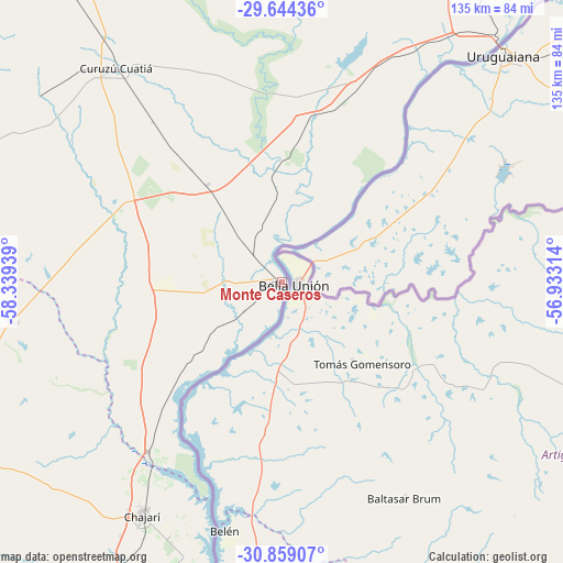
Monte Caseros GPS coordinates[2]
30° 15' 12.924" South, 57° 38' 10.536" West
| Map corner | latitude | longitude |
|---|---|---|
| Upper-left | -29.64436°, | -58.33939° |
| Center: | -30.25359°, | -57.63626° |
| Lower-right: | -30.85907°, | -56.93314° |
| Map W x H: | 135.1×135.1 km | = 83.9×83.9mi |
| max Lat: | -21.94467° ⇑36.1% North |
| Monte Caseros: | -30.25359° |
| min Lat: | ⇓63.9% South -54.81084° |
| min Long | Monte Caseros | max Long |
| -72.88605° | -57.63626° | -53.64581° |
| W 91.1%⇐ | ⇒8.9% E |
Elevation
Elevation of Monte Caseros is 53 m = 174 ft, and this is 296.3 m = 972 ft below average elevation for this country.
| Max E: |
4040 m = 13255 ft | 82.6% |
| Avg. | 349.3 m = 1146 ft | |
| Monte Caseros | 53 m = 174 ft | |
Min E: |
-2 m = -7 ft | 17.4% |
See also: Argentina elevation on elevation.city.
Geographical zone
Monte Caseros is located in South temperate zone (between Tropic of Capricorn and the Antarctic Circle). Distance of this Southern Tropic circle is 758 km =471 mi to North.| Distance of | km | miles | from Monte Caseros |
|---|---|---|---|
| Equator | 3363.9 | 2090.2 | to North |
| Tropic Capricorn | 758 | 471 | to North |
| Antarctic Circle | 4037.3 | 2508.7 | to South |
| South Pole | 6643.2 | 4127.9 | to South |


Nearby cities:
15 places around Monte Caseros: (largest is in red/bold)
• Bonpland
52.4 km =32.6 mi,  22°
22°
• Chajarí
64.3 km =40 mi,  210°
210°
• Curuzú Cuatiá
65.3 km =40.6 mi,  321°
321°
• Federación
87.4 km =54.3 mi,  196°
196°
• Juan Pujol
28 km =17.4 mi,  228°
228°
• Libertad
29.3 km =18.2 mi, 322°
• Los Conquistadores
88.1 km =54.7 mi,  244°
244°
• Mariano I. Loza
111.4 km =69.2 mi,  331°
331°
• Mocoretá
51.3 km =31.9 mi,  217°
217°
• Paso de los Libres
80.1 km =49.8 mi,  41°
41°
• San José de Feliciano
108 km =67.1 mi,  262°
262°
• Santa Ana
77.2 km =48 mi, 201°
• Sauce
112.2 km =69.7 mi,  279°
279°
• Tapebicuá
104.7 km =65.1 mi, 37°
• Villa del Rosario
65.8 km =40.9 mi, 203°
Sources, notices
• [Note1] Compared only with cities in Argentina existing in our database
• [Src1] Map data: © OpenStreetMap contributors (CC-BY-SA)
• [Src2] Other city data from geonames.org with taken over terms of usage.
• [Src3] Geographical zone / Annual Mean Temperature by Robert A. Rohde @ Wikipedia
