Federación geodata
Federación (Entre Rios) is a seat of a second-order administrative division; located in Argentina in America/Argentina/Cordoba (GMT-3) time zone. With population of 13,789 people, there are 241 cities with bigger population in this country. Compared to other cities in Argentina, 59.7% of cities are located further ↓South; 89.9% of cities are located further ←West and 85.2% of cities have higher elevation than Federación. Note1


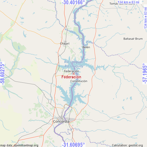
Federación GPS coordinates[2]
31° 0' 22.356" South, 57° 53' 58.632" West
| Map corner | latitude | longitude |
|---|---|---|
| Upper-left | -30.40166°, | -58.60275° |
| Center: | -31.00621°, | -57.89962° |
| Lower-right: | -31.60695°, | -57.1965° |
| Map W x H: | 134×134 km | = 83.3×83.3mi |
| max Lat: | -21.94467° ⇑40.3% North |
| Federación: | -31.00621° |
| min Lat: | ⇓59.7% South -54.81084° |
| min Long | Federación | max Long |
| -72.88605° | -57.89962° | -53.64581° |
| W 89.9%⇐ | ⇒10.1% E |
Elevation
Elevation of Federación is 46 m = 151 ft, and this is 303.3 m = 995 ft below average elevation for this country.
| Max E: |
4040 m = 13255 ft | 85.2% |
| Avg. | 349.3 m = 1146 ft | |
| Federación | 46 m = 151 ft | |
Min E: |
-2 m = -7 ft | 14.8% |
See also: Argentina elevation on elevation.city.
Geographical zone
Federación is located in South temperate zone (between Tropic of Capricorn and the Antarctic Circle). Distance of this Southern Tropic circle is 841.6 km =522.9 mi to North.| Distance of | km | miles | from Federación |
|---|---|---|---|
| Equator | 3447.6 | 2142.2 | to North |
| Tropic Capricorn | 841.6 | 522.9 | to North |
| Antarctic Circle | 3953.6 | 2456.7 | to South |
| South Pole | 6559.5 | 4075.9 | to South |


Nearby cities:
15 places around Federación: (largest is in red/bold)
• Chajarí
29.4 km =18.3 mi,  344°
344°
• Concordia
44.5 km =27.7 mi,  195°
195°
• Federal
84.4 km =52.4 mi,  273°
273°
• General Campos
74.9 km =46.5 mi,  219°
219°
• Juan Pujol
65.5 km =40.7 mi,  3°
3°
• La Criolla
35.2 km =21.9 mi,  213°
213°
• Los Charrúas
33.3 km =20.7 mi,  235°
235°
• Los Conquistadores
71.3 km =44.3 mi,  310°
310°
• Mocoretá
43.5 km =27 mi,  351°
351°
• Monte Caseros
87.4 km =54.3 mi,  16°
16°
• Puerto Yeruá
60 km =37.3 mi,  190°
190°
• San Salvador
89.7 km =55.7 mi, 219°
• Santa Ana
12.2 km =7.6 mi, 345°
• Ubajay
96 km =59.7 mi, 204°
• Villa del Rosario
23.4 km =14.5 mi,  356°
356°
Sources, notices
• [Note1] Compared only with cities in Argentina existing in our database
• [Src1] Map data: © OpenStreetMap contributors (CC-BY-SA)
• [Src2] Other city data from geonames.org with taken over terms of usage.
• [Src3] Geographical zone / Annual Mean Temperature by Robert A. Rohde @ Wikipedia
