Gobernador Roca geodata
Gobernador Roca (Misiones) is a populated place; located in Argentina in America/Argentina/Cordoba (GMT-3) time zone. With population of 6,315 people, there are 393 cities with bigger population in this country. Compared to other cities in Argentina, 84.6% of cities are located further ↓South; 95.6% of cities are located further ←West and 56.8% of cities have lower elevation than Gobernador Roca. Note1


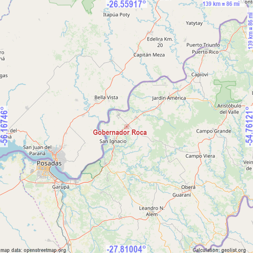
Gobernador Roca GPS coordinates[2]
27° 11' 10.896" South, 55° 27' 51.588" West
| Map corner | latitude | longitude |
|---|---|---|
| Upper-left | -26.55917°, | -56.16746° |
| Center: | -27.18636°, | -55.46433° |
| Lower-right: | -27.81004°, | -54.76121° |
| Map W x H: | 139.1×139.1 km | = 86.4×86.4mi |
| max Lat: | -21.94467° ⇑15.4% North |
| Gobernador Roca: | -27.18636° |
| min Lat: | ⇓84.6% South -54.81084° |
| min Long | Gobernador Roca | max Long |
| -72.88605° | -55.46433° | -53.64581° |
| W 95.6%⇐ | ⇒4.4% E |
Elevation
Elevation of Gobernador Roca is 185 m = 607 ft, and this is 164.3 m = 539 ft below average elevation for this country.
| Max E: |
4040 m = 13255 ft | 43.2% |
| Avg. | 349.3 m = 1146 ft | |
| Gobernador Roca | 185 m = 607 ft | |
Min E: |
-2 m = -7 ft | 56.8% |
See also: Argentina elevation on elevation.city.
Geographical zone
Gobernador Roca is located in South temperate zone (between Tropic of Capricorn and the Antarctic Circle). Distance of this Southern Tropic circle is 416.9 km =259 mi to North.| Distance of | km | miles | from Gobernador Roca |
|---|---|---|---|
| Equator | 3022.8 | 1878.3 | to North |
| Tropic Capricorn | 416.9 | 259 | to North |
| Antarctic Circle | 4378.3 | 2720.5 | to South |
| South Pole | 6984.2 | 4339.8 | to South |


Nearby cities:
15 places around Gobernador Roca: (largest is in red/bold)
• Almafuerte
36.3 km =22.6 mi,  170°
170°
• Bonpland
32.9 km =20.4 mi,  182°
182°
• Campo Viera
43.5 km =27 mi,  111°
111°
• Candelaria
41.1 km =25.5 mi,  222°
222°
• Cerro Corá
39 km =24.2 mi,  201°
201°
• General Alvear
39.5 km =24.5 mi,  132°
132°
• Jardín América
28.4 km =17.6 mi,  55°
55°
• Loreto
17.2 km =10.7 mi, 200°
• Mártires
27.7 km =17.2 mi,  161°
161°
• Posadas
47.2 km =29.3 mi,  244°
244°
• Puerto Leoni
36.9 km =22.9 mi,  53°
53°
• Ruiz de Montoya
46.8 km =29.1 mi, 61°
• San Ignacio
10.3 km =6.4 mi, 221°
• Santa Ana
23.2 km =14.4 mi,  209°
209°
• Santo Pipó
7.4 km =4.6 mi, 47°
Sources, notices
• [Note1] Compared only with cities in Argentina existing in our database
• [Src1] Map data: © OpenStreetMap contributors (CC-BY-SA)
• [Src2] Other city data from geonames.org with taken over terms of usage.
• [Src3] Geographical zone / Annual Mean Temperature by Robert A. Rohde @ Wikipedia
