Goya geodata
Goya (Corrientes) is a seat of a second-order administrative division; located in Argentina in America/Argentina/Cordoba (GMT-3) time zone. With population of 70,245 people, there are 63 cities with bigger population in this country. Compared to other cities in Argentina, 68.1% of cities are located further ↓South; 74.1% of cities are located further ←West and 91.9% of cities have higher elevation than Goya. Note1


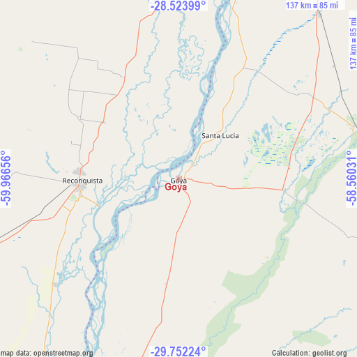
Goya GPS coordinates[2]
29° 8' 23.82" South, 59° 15' 48.348" West
| Map corner | latitude | longitude |
|---|---|---|
| Upper-left | -28.52399°, | -59.96656° |
| Center: | -29.13995°, | -59.26343° |
| Lower-right: | -29.75224°, | -58.56031° |
| Map W x H: | 136.6×136.6 km | = 84.9×84.9mi |
| max Lat: | -21.94467° ⇑31.9% North |
| Goya: | -29.13995° |
| min Lat: | ⇓68.1% South -54.81084° |
| min Long | Goya | max Long |
| -72.88605° | -59.26343° | -53.64581° |
| W 74.1%⇐ | ⇒25.9% E |
Elevation
Elevation of Goya is 25 m = 82 ft, and this is 324.3 m = 1064 ft below average elevation for this country.
| Max E: |
4040 m = 13255 ft | 91.9% |
| Avg. | 349.3 m = 1146 ft | |
| Goya | 25 m = 82 ft | |
Min E: |
-2 m = -7 ft | 8.1% |
See also: Goya elevation on elevation.city.
Geographical zone
Goya is located in South temperate zone (between Tropic of Capricorn and the Antarctic Circle). Distance of this Southern Tropic circle is 634.1 km =394 mi to North.| Distance of | km | miles | from Goya |
|---|---|---|---|
| Equator | 3240.1 | 2013.3 | to North |
| Tropic Capricorn | 634.1 | 394 | to North |
| Antarctic Circle | 4161.1 | 2585.6 | to South |
| South Pole | 6767 | 4204.8 | to South |


Nearby cities:
15 places around Goya: (largest is in red/bold)
• Avellaneda
38.4 km =23.9 mi,  273°
273°
• Bella Vista
73.6 km =45.7 mi,  17°
17°
• Chavarría
70.2 km =43.6 mi,  72°
72°
• Cruz de los Milagros
42.1 km =26.2 mi,  36°
36°
• Gobernador Juan E. Martínez
40.7 km =25.3 mi,  51°
51°
• Los Laureles
52.4 km =32.6 mi,  241°
241°
• Malabrigo
72.3 km =44.9 mi,  251°
251°
• Nueve de Julio
54 km =33.6 mi, 51°
• Pedro R. Fernández
73.3 km =45.5 mi, 53°
• Perugorría
67.2 km =41.8 mi,  109°
109°
• Reconquista
37.6 km =23.4 mi, 268°
• Santa Lucía
23 km =14.3 mi, 42°
• Tacuarendí
80.9 km =50.3 mi,  0°
0°
• Villa Ocampo
73.1 km =45.4 mi,  352°
352°
• Yataity Calle
37 km =23 mi, 68°
Sources, notices
• [Note1] Compared only with cities in Argentina existing in our database
• [Src1] Map data: © OpenStreetMap contributors (CC-BY-SA)
• [Src2] Other city data from geonames.org with taken over terms of usage.
• [Src3] Geographical zone / Annual Mean Temperature by Robert A. Rohde @ Wikipedia
