Avellaneda geodata
Avellaneda (Santa Fe) is a populated place; located in Argentina in America/Argentina/Cordoba (GMT-3) time zone. With population of 23,077 people, there are 173 cities with bigger population in this country. Compared to other cities in Argentina, 68.2% of cities are located further ↓South; 70.6% of cities are located further ←West and 83.3% of cities have higher elevation than Avellaneda. Note1


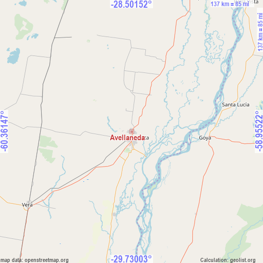
Avellaneda GPS coordinates[2]
29° 7' 3.396" South, 59° 39' 30.024" West
| Map corner | latitude | longitude |
|---|---|---|
| Upper-left | -28.50152°, | -60.36147° |
| Center: | -29.11761°, | -59.65834° |
| Lower-right: | -29.73003°, | -58.95522° |
| Map W x H: | 136.6×136.6 km | = 84.9×84.9mi |
| max Lat: | -21.94467° ⇑31.8% North |
| Avellaneda: | -29.11761° |
| min Lat: | ⇓68.2% South -54.81084° |
| min Long | Avellaneda | max Long |
| -72.88605° | -59.65834° | -53.64581° |
| W 70.6%⇐ | ⇒29.4% E |
Elevation
Elevation of Avellaneda is 52 m = 171 ft, and this is 297.3 m = 975 ft below average elevation for this country.
| Max E: |
4040 m = 13255 ft | 83.3% |
| Avg. | 349.3 m = 1146 ft | |
| Avellaneda | 52 m = 171 ft | |
Min E: |
-2 m = -7 ft | 16.7% |
See also: Argentina elevation on elevation.city.
Geographical zone
Avellaneda is located in South temperate zone (between Tropic of Capricorn and the Antarctic Circle). Distance of this Southern Tropic circle is 631.7 km =392.5 mi to North.| Distance of | km | miles | from Avellaneda |
|---|---|---|---|
| Equator | 3237.6 | 2011.8 | to North |
| Tropic Capricorn | 631.7 | 392.5 | to North |
| Antarctic Circle | 4163.6 | 2587.1 | to South |
| South Pole | 6769.5 | 4206.4 | to South |


Nearby cities:
15 places around Avellaneda: (largest is in red/bold)
• Bella Vista
90.6 km =56.3 mi,  41°
41°
• Cruz de los Milagros
70.8 km =44 mi,  63°
63°
• Esquina
100.5 km =62.4 mi,  172°
172°
• Gobernador Juan E. Martínez
73.9 km =45.9 mi,  71°
71°
• Goya
38.4 km =23.9 mi,  93°
93°
• Las Toscas
93.6 km =58.2 mi,  24°
24°
• Los Laureles
28.9 km =18 mi,  195°
195°
• Malabrigo
39.5 km =24.5 mi,  229°
229°
• Nueve de Julio
86.6 km =53.8 mi, 69°
• Reconquista
3.7 km =2.3 mi, 167°
• Santa Lucía
55.9 km =34.7 mi, 74°
• Tacuarendí
87.5 km =54.4 mi,  26°
26°
• Vera
65.8 km =40.9 mi, 234°
• Villa Ocampo
76 km =47.2 mi, 22°
• Yataity Calle
73.7 km =45.8 mi,  81°
81°
Sources, notices
• [Note1] Compared only with cities in Argentina existing in our database
• [Src1] Map data: © OpenStreetMap contributors (CC-BY-SA)
• [Src2] Other city data from geonames.org with taken over terms of usage.
• [Src3] Geographical zone / Annual Mean Temperature by Robert A. Rohde @ Wikipedia
