Trenel geodata
Trenel (La Pampa) is a seat of a second-order administrative division; located in Argentina in America/Argentina/Salta (GMT-3) time zone. With population of 3,426 people, there are 526 cities with bigger population in this country. Compared to other cities in Argentina, 80.9% of cities are located further ↑North; 62.9% of cities are located further →East and 56.1% of cities have lower elevation than Trenel. Note1


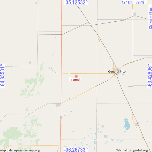
Trenel GPS coordinates[2]
35° 41' 54.132" South, 64° 7' 55.848" West
| Map corner | latitude | longitude |
|---|---|---|
| Upper-left | -35.12532°, | -64.83531° |
| Center: | -35.69837°, | -64.13218° |
| Lower-right: | -36.26733°, | -63.42906° |
| Map W x H: | 127×127 km | = 78.9×78.9mi |
| max Lat: | -21.94467° ⇑80.9% North |
| Trenel: | -35.69837° |
| min Lat: | ⇓19.1% South -54.81084° |
| min Long | Trenel | max Long |
| -72.88605° | -64.13218° | -53.64581° |
| W 37.1%⇐ | ⇒62.9% E |
Elevation
Elevation of Trenel is 179 m = 587 ft, and this is 170.3 m = 559 ft below average elevation for this country.
| Max E: |
4040 m = 13255 ft | 43.9% |
| Avg. | 349.3 m = 1146 ft | |
| Trenel | 179 m = 587 ft | |
Min E: |
-2 m = -7 ft | 56.1% |
See also: Argentina elevation on elevation.city.
Geographical zone
Trenel is located in South temperate zone (between Tropic of Capricorn and the Antarctic Circle). Distance of this Southern Tropic circle is 1363.4 km =847.2 mi to North.| Distance of | km | miles | from Trenel |
|---|---|---|---|
| Equator | 3969.3 | 2466.4 | to North |
| Tropic Capricorn | 1363.4 | 847.2 | to North |
| Antarctic Circle | 3431.9 | 2132.5 | to South |
| South Pole | 6037.8 | 3751.7 | to South |


Nearby cities:
15 places around Trenel: (largest is in red/bold)
• Alta Italia
40.6 km =25.2 mi,  2°
2°
• Arata
21.3 km =13.2 mi,  288°
288°
• Caleufú
40.1 km =24.9 mi, 286°
• Colonia Barón
56.3 km =35 mi,  153°
153°
• Eduardo Castex
28.2 km =17.5 mi,  211°
211°
• Embajador Martini
37.2 km =23.1 mi,  338°
338°
• General Pico
34.2 km =21.3 mi,  82°
82°
• Ingeniero Luiggi
46 km =28.6 mi,  319°
319°
• Intendente Alvear
71.1 km =44.2 mi,  43°
43°
• La Maruja
73 km =45.4 mi,  272°
272°
• Parera
69.9 km =43.4 mi,  331°
331°
• Quemú Quemú
64.7 km =40.2 mi,  127°
127°
• Rancul
85.9 km =53.4 mi, 324°
• Realicó
74.3 km =46.2 mi,  352°
352°
• Winifreda
59.4 km =36.9 mi,  188°
188°
Sources, notices
• [Note1] Compared only with cities in Argentina existing in our database
• [Src1] Map data: © OpenStreetMap contributors (CC-BY-SA)
• [Src2] Other city data from geonames.org with taken over terms of usage.
• [Src3] Geographical zone / Annual Mean Temperature by Robert A. Rohde @ Wikipedia
