Quemú Quemú geodata
Quemú Quemú (La Pampa) is a seat of a second-order administrative division; located in Argentina in America/Argentina/Salta (GMT-3) time zone. With population of 3,851 people, there are 499 cities with bigger population in this country. Compared to other cities in Argentina, 81.7% of cities are located further ↑North; 56.3% of cities are located further →East and 55.5% of cities have higher elevation than Quemú Quemú. Note1


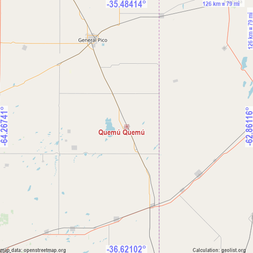
Quemú Quemú GPS coordinates[2]
36° 3' 16.668" South, 63° 33' 51.408" West
| Map corner | latitude | longitude |
|---|---|---|
| Upper-left | -35.48414°, | -64.26741° |
| Center: | -36.05463°, | -63.56428° |
| Lower-right: | -36.62102°, | -62.86116° |
| Map W x H: | 126.4×126.4 km | = 78.5×78.5mi |
| max Lat: | -21.94467° ⇑81.7% North |
| Quemú Quemú: | -36.05463° |
| min Lat: | ⇓18.3% South -54.81084° |
| min Long | Quemú Quemú | max Long |
| -72.88605° | -63.56428° | -53.64581° |
| W 43.7%⇐ | ⇒56.3% E |
Elevation
Elevation of Quemú Quemú is 121 m = 397 ft, and this is 228.3 m = 749 ft below average elevation for this country.
| Max E: |
4040 m = 13255 ft | 55.5% |
| Avg. | 349.3 m = 1146 ft | |
| Quemú Quemú | 121 m = 397 ft | |
Min E: |
-2 m = -7 ft | 44.5% |
See also: Argentina elevation on elevation.city.
Geographical zone
Quemú Quemú is located in South temperate zone (between Tropic of Capricorn and the Antarctic Circle). Distance of this Southern Tropic circle is 1403 km =871.8 mi to North.| Distance of | km | miles | from Quemú Quemú |
|---|---|---|---|
| Equator | 4008.9 | 2491 | to North |
| Tropic Capricorn | 1403 | 871.8 | to North |
| Antarctic Circle | 3392.3 | 2107.9 | to South |
| South Pole | 5998.2 | 3727.1 | to South |


Nearby cities:
15 places around Quemú Quemú: (largest is in red/bold)
• Anguil
65.9 km =40.9 mi,  217°
217°
• Arata
85 km =52.8 mi,  302°
302°
• Catriló
41.1 km =25.5 mi,  161°
161°
• Colonia Barón
28.2 km =17.5 mi,  247°
247°
• Eduardo Castex
67.5 km =41.9 mi,  283°
283°
• General Pico
47.5 km =29.5 mi,  338°
338°
• Lonquimay
46 km =28.6 mi,  186°
186°
• Miguel Riglos
89.6 km =55.7 mi, 187°
• Pellegrini
42.8 km =26.6 mi,  123°
123°
• Santa Rosa
89.7 km =55.7 mi,  225°
225°
• Trenel
64.7 km =40.2 mi,  307°
307°
• Trenque Lauquen
75.2 km =46.7 mi,  82°
82°
• Tres Lomas
77.4 km =48.1 mi,  125°
125°
• Uriburu
56.9 km =35.4 mi,  207°
207°
• Winifreda
63.1 km =39.2 mi, 252°
Sources, notices
• [Note1] Compared only with cities in Argentina existing in our database
• [Src1] Map data: © OpenStreetMap contributors (CC-BY-SA)
• [Src2] Other city data from geonames.org with taken over terms of usage.
• [Src3] Geographical zone / Annual Mean Temperature by Robert A. Rohde @ Wikipedia
