Guachipas geodata
Guachipas (Salta) is a seat of a second-order administrative division; located in Argentina in America/Argentina/Salta (GMT-3) time zone. In our database, there are 785 cities with bigger population. Compared to other cities in Argentina, 93.5% of cities are located further ↓South; 78.2% of cities are located further →East and 93.3% of cities have lower elevation than Guachipas. Note1


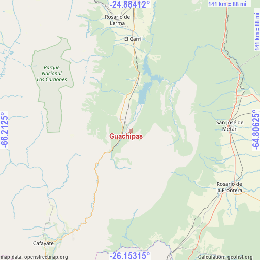
Guachipas GPS coordinates[2]
25° 31' 13.116" South, 65° 30' 33.732" West
| Map corner | latitude | longitude |
|---|---|---|
| Upper-left | -24.88412°, | -66.2125° |
| Center: | -25.52031°, | -65.50937° |
| Lower-right: | -26.15315°, | -64.80625° |
| Map W x H: | 141.1×141.1 km | = 87.7×87.7mi |
| max Lat: | -21.94467° ⇑6.5% North |
| Guachipas: | -25.52031° |
| min Lat: | ⇓93.5% South -54.81084° |
| min Long | Guachipas | max Long |
| -72.88605° | -65.50937° | -53.64581° |
| W 21.8%⇐ | ⇒78.2% E |
Elevation
Elevation of Guachipas is 1096 m = 3596 ft, and this is 746.7 m = 2450 ft above average elevation for this country.
| Max E: |
4040 m = 13255 ft | 6.7% |
| Guachipas | 1096 m 3596 ft | |
| Avg. | 349.3 m = 1146 ft | |
Min E: |
-2 m = -7 ft | 93.3% |
See also: Argentina elevation on elevation.city.
Geographical zone
Guachipas is located in South temperate zone (between Tropic of Capricorn and the Antarctic Circle). Distance of this Southern Tropic circle is 231.7 km =144 mi to North.| Distance of | km | miles | from Guachipas |
|---|---|---|---|
| Equator | 2837.6 | 1763.2 | to North |
| Tropic Capricorn | 231.7 | 144 | to North |
| Antarctic Circle | 4563.6 | 2835.7 | to South |
| South Pole | 7169.5 | 4454.9 | to South |


Nearby cities:
15 places around Guachipas: (largest is in red/bold)
• Cachí
79.5 km =49.4 mi,  304°
304°
• Cafayate
77.3 km =48 mi,  217°
217°
• Campo Quijano
69.1 km =42.9 mi,  349°
349°
• Cerrillos
69.2 km =43 mi,  1°
1°
• Chicoana
46.2 km =28.7 mi,  356°
356°
• El Carril
49.6 km =30.8 mi, 2°
• La Candelaria
81.7 km =50.8 mi,  145°
145°
• La Viña
8.3 km =5.2 mi,  316°
316°
• Metán
53.8 km =33.4 mi,  87°
87°
• Molinos
79.3 km =49.3 mi,  276°
276°
• Rosario de Lerma
60.3 km =37.5 mi, 353°
• Rosario de la Frontera
62.1 km =38.6 mi,  119°
119°
• Salta
82.2 km =51.1 mi,  6°
6°
• San Carlos
58.5 km =36.4 mi,  225°
225°
• Trancas
82.3 km =51.1 mi,  163°
163°
Sources, notices
• [Note1] Compared only with cities in Argentina existing in our database
• [Src1] Map data: © OpenStreetMap contributors (CC-BY-SA)
• [Src2] Other city data from geonames.org with taken over terms of usage.
• [Src3] Geographical zone / Annual Mean Temperature by Robert A. Rohde @ Wikipedia
