Ramallo geodata
Ramallo (Buenos Aires) is a seat of a second-order administrative division; located in Argentina in America/Argentina/Buenos_Aires (GMT-3) time zone. In our database, there are 785 cities with bigger population. Compared to other cities in Argentina, 66.5% of cities are located further ↑North; 68.1% of cities are located further ←West and 93.1% of cities have higher elevation than Ramallo. Note1


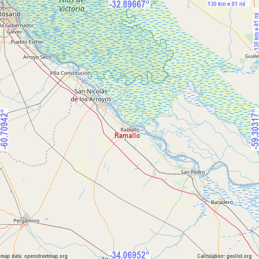
Ramallo GPS coordinates[2]
33° 29' 6.288" South, 60° 0' 22.644" West
| Map corner | latitude | longitude |
|---|---|---|
| Upper-left | -32.89667°, | -60.70942° |
| Center: | -33.48508°, | -60.00629° |
| Lower-right: | -34.06952°, | -59.30317° |
| Map W x H: | 130.4×130.4 km | = 81×81mi |
| max Lat: | -21.94467° ⇑66.5% North |
| Ramallo: | -33.48508° |
| min Lat: | ⇓33.5% South -54.81084° |
| min Long | Ramallo | max Long |
| -72.88605° | -60.00629° | -53.64581° |
| W 68.1%⇐ | ⇒31.9% E |
Elevation
Elevation of Ramallo is 23 m = 75 ft, and this is 326.3 m = 1071 ft below average elevation for this country.
| Max E: |
4040 m = 13255 ft | 93.1% |
| Avg. | 349.3 m = 1146 ft | |
| Ramallo | 23 m = 75 ft | |
Min E: |
-2 m = -7 ft | 6.9% |
See also: Argentina elevation on elevation.city.
Geographical zone
Ramallo is located in South temperate zone (between Tropic of Capricorn and the Antarctic Circle). Distance of this Southern Tropic circle is 1117.3 km =694.3 mi to North.| Distance of | km | miles | from Ramallo |
|---|---|---|---|
| Equator | 3723.2 | 2313.5 | to North |
| Tropic Capricorn | 1117.3 | 694.3 | to North |
| Antarctic Circle | 3678 | 2285.4 | to South |
| South Pole | 6283.9 | 3904.6 | to South |


Nearby cities:
15 places around Ramallo: (largest is in red/bold)
• Arrecifes
65 km =40.4 mi,  187°
187°
• Arroyo Seco
59.4 km =36.9 mi,  308°
308°
• Baradero
58.7 km =36.5 mi,  128°
128°
• Capitán Sarmiento
79 km =49.1 mi,  165°
165°
• Gobernador Gálvez
77.7 km =48.3 mi, 310°
• Granadero Baigorria
96.2 km =59.8 mi,  316°
316°
• Gualeguay
75.2 km =46.7 mi,  59°
59°
• Pergamino
69.1 km =42.9 mi,  229°
229°
• Puerto Ibicuy
82.3 km =51.1 mi,  111°
111°
• Pérez
89.1 km =55.4 mi, 307°
• Rosario
84 km =52.2 mi, 315°
• Salto
92.7 km =57.6 mi, 194°
• San Nicolás de los Arroyos
25.3 km =15.7 mi, 311°
• San Pedro
38.2 km =23.7 mi,  124°
124°
• Villa Constitución
41.5 km =25.8 mi, 313°
Sources, notices
• [Note1] Compared only with cities in Argentina existing in our database
• [Src1] Map data: © OpenStreetMap contributors (CC-BY-SA)
• [Src2] Other city data from geonames.org with taken over terms of usage.
• [Src3] Geographical zone / Annual Mean Temperature by Robert A. Rohde @ Wikipedia
