Oncativo geodata
Oncativo (Cordoba) is a populated place; located in Argentina in America/Argentina/Cordoba (GMT-3) time zone. With population of 12,660 people, there are 249 cities with bigger population in this country. Compared to other cities in Argentina, 50.9% of cities are located further ↑North; 57.4% of cities are located further →East and 65.6% of cities have lower elevation than Oncativo. Note1


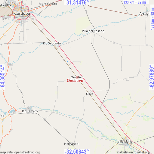
Oncativo GPS coordinates[2]
31° 54' 48.708" South, 63° 40' 55.236" West
| Map corner | latitude | longitude |
|---|---|---|
| Upper-left | -31.31476°, | -64.38514° |
| Center: | -31.91353°, | -63.68201° |
| Lower-right: | -32.50843°, | -62.97889° |
| Map W x H: | 132.7×132.7 km | = 82.5×82.5mi |
| max Lat: | -21.94467° ⇑50.9% North |
| Oncativo: | -31.91353° |
| min Lat: | ⇓49.1% South -54.81084° |
| min Long | Oncativo | max Long |
| -72.88605° | -63.68201° | -53.64581° |
| W 42.6%⇐ | ⇒57.4% E |
Elevation
Elevation of Oncativo is 283 m = 928 ft, and this is 66.3 m = 218 ft below average elevation for this country.
| Max E: |
4040 m = 13255 ft | 34.4% |
| Avg. | 349.3 m = 1146 ft | |
| Oncativo | 283 m = 928 ft | |
Min E: |
-2 m = -7 ft | 65.6% |
See also: Argentina elevation on elevation.city.
Geographical zone
Oncativo is located in South temperate zone (between Tropic of Capricorn and the Antarctic Circle). Distance of this Southern Tropic circle is 942.5 km =585.6 mi to North.| Distance of | km | miles | from Oncativo |
|---|---|---|---|
| Equator | 3548.5 | 2204.9 | to North |
| Tropic Capricorn | 942.5 | 585.6 | to North |
| Antarctic Circle | 3852.7 | 2394 | to South |
| South Pole | 6458.6 | 4013.2 | to South |


Nearby cities:
15 places around Oncativo: (largest is in red/bold)
• Carrilobo
53.5 km =33.2 mi,  85°
85°
• Corralito
49.7 km =30.9 mi,  255°
255°
• Costa Sacate
30.4 km =18.9 mi,  346°
346°
• James Craik
34.2 km =21.3 mi,  143°
143°
• Laguna Larga
18.9 km =11.7 mi,  323°
323°
• Las Junturas
23.7 km =14.7 mi,  67°
67°
• Oliva
17.7 km =11 mi, 143°
• Pilar
32.1 km =19.9 mi, 324°
• Río Segundo
36.1 km =22.4 mi, 323°
• Río Tercero
49.9 km =31 mi,  234°
234°
• Tancacha
46.2 km =28.7 mi,  217°
217°
• Toledo
50.4 km =31.3 mi, 322°
• Tío Pujio
51.7 km =32.1 mi, 143°
• Villa Ascasubi
34.1 km =21.2 mi, 215°
• Villa del Rosario
42.1 km =26.2 mi,  19°
19°
Sources, notices
• [Note1] Compared only with cities in Argentina existing in our database
• [Src1] Map data: © OpenStreetMap contributors (CC-BY-SA)
• [Src2] Other city data from geonames.org with taken over terms of usage.
• [Src3] Geographical zone / Annual Mean Temperature by Robert A. Rohde @ Wikipedia
