Villa Ascasubi geodata
Villa Ascasubi (Cordoba) is a populated place; located in Argentina in America/Argentina/Cordoba (GMT-3) time zone. With population of 2,081 people, there are 637 cities with bigger population in this country. Compared to other cities in Argentina, 53% of cities are located further ↑North; 59.9% of cities are located further →East and 69.7% of cities have lower elevation than Villa Ascasubi. Note1


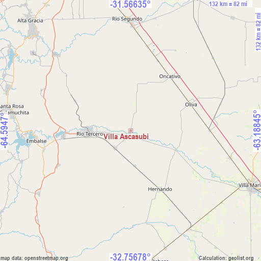
Villa Ascasubi GPS coordinates[2]
32° 9' 48.636" South, 63° 53' 29.652" West
| Map corner | latitude | longitude |
|---|---|---|
| Upper-left | -31.56635°, | -64.5947° |
| Center: | -32.16351°, | -63.89157° |
| Lower-right: | -32.75678°, | -63.18845° |
| Map W x H: | 132.4×132.4 km | = 82.3×82.3mi |
| max Lat: | -21.94467° ⇑53% North |
| Villa Ascasubi: | -32.16351° |
| min Lat: | ⇓47% South -54.81084° |
| min Long | Villa Ascasubi | max Long |
| -72.88605° | -63.89157° | -53.64581° |
| W 40.1%⇐ | ⇒59.9% E |
Elevation
Elevation of Villa Ascasubi is 337 m = 1106 ft, and this is 12.3 m = 40 ft below average elevation for this country.
| Max E: |
4040 m = 13255 ft | 30.3% |
| Avg. | 349.3 m = 1146 ft | |
| Villa Ascasubi | 337 m = 1106 ft | |
Min E: |
-2 m = -7 ft | 69.7% |
See also: Argentina elevation on elevation.city.
Geographical zone
Villa Ascasubi is located in South temperate zone (between Tropic of Capricorn and the Antarctic Circle). Distance of this Southern Tropic circle is 970.3 km =602.9 mi to North.| Distance of | km | miles | from Villa Ascasubi |
|---|---|---|---|
| Equator | 3576.2 | 2222.1 | to North |
| Tropic Capricorn | 970.3 | 602.9 | to North |
| Antarctic Circle | 3824.9 | 2376.7 | to South |
| South Pole | 6430.8 | 3995.9 | to South |


Nearby cities:
15 places around Villa Ascasubi: (largest is in red/bold)
• Almafuerte
34.4 km =21.4 mi,  264°
264°
• Corralito
32.3 km =20.1 mi,  298°
298°
• Embalse
49.6 km =30.8 mi,  267°
267°
• Hernando
32.8 km =20.4 mi,  153°
153°
• James Craik
40 km =24.9 mi,  89°
89°
• Laguna Larga
43.9 km =27.3 mi,  11°
11°
• Los Cóndores
40.2 km =25 mi,  244°
244°
• Oliva
33.2 km =20.6 mi,  65°
65°
• Oncativo
34.1 km =21.2 mi,  35°
35°
• Pilar
53.9 km =33.5 mi,  1°
1°
• Río Tercero
21 km =13 mi, 267°
• San Agustín
50 km =31.1 mi,  294°
294°
• Tancacha
12.2 km =7.6 mi,  223°
223°
• Tío Pujio
52.2 km =32.4 mi,  105°
105°
• Villa del Dique
53.1 km =33 mi, 268°
Sources, notices
• [Note1] Compared only with cities in Argentina existing in our database
• [Src1] Map data: © OpenStreetMap contributors (CC-BY-SA)
• [Src2] Other city data from geonames.org with taken over terms of usage.
• [Src3] Geographical zone / Annual Mean Temperature by Robert A. Rohde @ Wikipedia
