Laguna Larga geodata
Laguna Larga (Cordoba) is a populated place; located in Argentina in America/Argentina/Cordoba (GMT-3) time zone. With population of 7,137 people, there are 357 cities with bigger population in this country. Compared to other cities in Argentina, 50.5% of cities are located further ↓South; 59% of cities are located further →East and 67.9% of cities have lower elevation than Laguna Larga. Note1


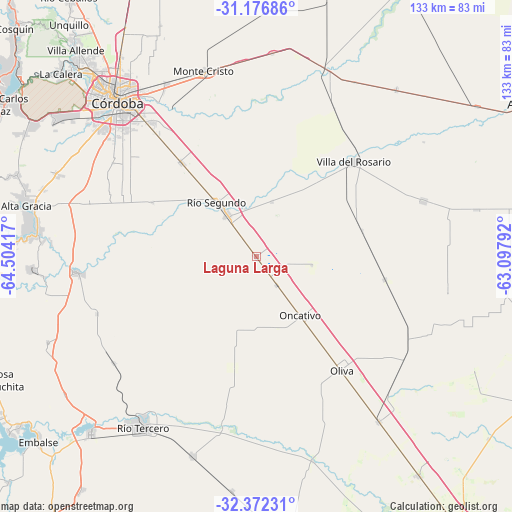
Laguna Larga GPS coordinates[2]
31° 46' 35.472" South, 63° 48' 3.744" West
| Map corner | latitude | longitude |
|---|---|---|
| Upper-left | -31.17686°, | -64.50417° |
| Center: | -31.77652°, | -63.80104° |
| Lower-right: | -32.37231°, | -63.09792° |
| Map W x H: | 132.9×132.9 km | = 82.6×82.6mi |
| max Lat: | -21.94467° ⇑49.5% North |
| Laguna Larga: | -31.77652° |
| min Lat: | ⇓50.5% South -54.81084° |
| min Long | Laguna Larga | max Long |
| -72.88605° | -63.80104° | -53.64581° |
| W 41%⇐ | ⇒59% E |
Elevation
Elevation of Laguna Larga is 308 m = 1010 ft, and this is 41.3 m = 135 ft below average elevation for this country.
| Max E: |
4040 m = 13255 ft | 32.1% |
| Avg. | 349.3 m = 1146 ft | |
| Laguna Larga | 308 m = 1010 ft | |
Min E: |
-2 m = -7 ft | 67.9% |
See also: Argentina elevation on elevation.city.
Geographical zone
Laguna Larga is located in South temperate zone (between Tropic of Capricorn and the Antarctic Circle). Distance of this Southern Tropic circle is 927.3 km =576.2 mi to North.| Distance of | km | miles | from Laguna Larga |
|---|---|---|---|
| Equator | 3533.2 | 2195.4 | to North |
| Tropic Capricorn | 927.3 | 576.2 | to North |
| Antarctic Circle | 3868 | 2403.5 | to South |
| South Pole | 6473.8 | 4022.6 | to South |


Nearby cities:
15 places around Laguna Larga: (largest is in red/bold)
• Corralito
46.1 km =28.6 mi,  233°
233°
• Costa Sacate
14.9 km =9.3 mi,  15°
15°
• Despeñaderos
46.4 km =28.8 mi,  264°
264°
• James Craik
53.1 km =33 mi,  143°
143°
• Las Junturas
33.7 km =20.9 mi,  100°
100°
• Malvinas Argentinas
50.1 km =31.1 mi,  331°
331°
• Monte Cristo
50.1 km =31.1 mi,  344°
344°
• Oliva
36.7 km =22.8 mi, 143°
• Oncativo
18.9 km =11.7 mi, 143°
• Pilar
13.2 km =8.2 mi, 325°
• Piquillín
53 km =32.9 mi,  4°
4°
• Río Segundo
17.2 km =10.7 mi,  323°
323°
• Toledo
31.5 km =19.6 mi, 321°
• Villa Ascasubi
43.9 km =27.3 mi,  191°
191°
• Villa del Rosario
35.1 km =21.8 mi,  45°
45°
Sources, notices
• [Note1] Compared only with cities in Argentina existing in our database
• [Src1] Map data: © OpenStreetMap contributors (CC-BY-SA)
• [Src2] Other city data from geonames.org with taken over terms of usage.
• [Src3] Geographical zone / Annual Mean Temperature by Robert A. Rohde @ Wikipedia
