Tancacha geodata
Tancacha (Cordoba) is a populated place; located in Argentina in America/Argentina/Cordoba (GMT-3) time zone. With population of 5,184 people, there are 437 cities with bigger population in this country. Compared to other cities in Argentina, 54.3% of cities are located further ↑North; 60.9% of cities are located further →East and 70.6% of cities have lower elevation than Tancacha. Note1


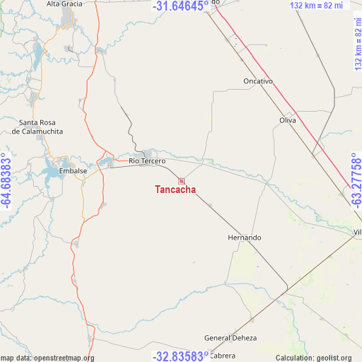
Tancacha GPS coordinates[2]
32° 14' 35.124" South, 63° 58' 50.52" West
| Map corner | latitude | longitude |
|---|---|---|
| Upper-left | -31.64645°, | -64.68383° |
| Center: | -32.24309°, | -63.9807° |
| Lower-right: | -32.83583°, | -63.27758° |
| Map W x H: | 132.2×132.2 km | = 82.1×82.1mi |
| max Lat: | -21.94467° ⇑54.3% North |
| Tancacha: | -32.24309° |
| min Lat: | ⇓45.7% South -54.81084° |
| min Long | Tancacha | max Long |
| -72.88605° | -63.9807° | -53.64581° |
| W 39.1%⇐ | ⇒60.9% E |
Elevation
Elevation of Tancacha is 354 m = 1161 ft, and this is 4.7 m = 15 ft above average elevation for this country.
| Max E: |
4040 m = 13255 ft | 29.4% |
| Tancacha | 354 m 1161 ft | |
| Avg. | 349.3 m = 1146 ft | |
Min E: |
-2 m = -7 ft | 70.6% |
See also: Argentina elevation on elevation.city.
Geographical zone
Tancacha is located in South temperate zone (between Tropic of Capricorn and the Antarctic Circle). Distance of this Southern Tropic circle is 979.2 km =608.4 mi to North.| Distance of | km | miles | from Tancacha |
|---|---|---|---|
| Equator | 3585.1 | 2227.7 | to North |
| Tropic Capricorn | 979.2 | 608.4 | to North |
| Antarctic Circle | 3816.1 | 2371.2 | to South |
| South Pole | 6422 | 3990.4 | to South |


Nearby cities:
15 places around Tancacha: (largest is in red/bold)
• Almafuerte
26.5 km =16.5 mi,  282°
282°
• Berrotarán
44.8 km =27.8 mi,  238°
238°
• Corralito
31.4 km =19.5 mi,  320°
320°
• Elena
53.4 km =33.2 mi,  226°
226°
• Embalse
41.7 km =25.9 mi, 279°
• Hernando
30.9 km =19.2 mi,  131°
131°
• James Craik
49.2 km =30.6 mi,  79°
79°
• Los Cóndores
29.2 km =18.1 mi,  252°
252°
• Oliva
44.7 km =27.8 mi,  59°
59°
• Oncativo
46.2 km =28.7 mi,  37°
37°
• Río Tercero
14.8 km =9.2 mi,  301°
301°
• San Agustín
47.4 km =29.5 mi,  308°
308°
• Villa Ascasubi
12.2 km =7.6 mi, 43°
• Villa Rumipal
47.4 km =29.5 mi, 277°
• Villa del Dique
45.3 km =28.1 mi, 279°
Sources, notices
• [Note1] Compared only with cities in Argentina existing in our database
• [Src1] Map data: © OpenStreetMap contributors (CC-BY-SA)
• [Src2] Other city data from geonames.org with taken over terms of usage.
• [Src3] Geographical zone / Annual Mean Temperature by Robert A. Rohde @ Wikipedia
