Gobernador Costa geodata
Gobernador Costa (Chubut) is a populated place; located in Argentina in America/Argentina/Catamarca (GMT-3) time zone. With population of 2,185 people, there are 621 cities with bigger population in this country. Compared to other cities in Argentina, 97.3% of cities are located further ↑North; 97.3% of cities are located further →East and 86.2% of cities have lower elevation than Gobernador Costa. Note1


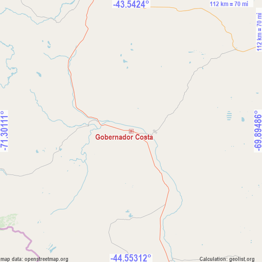
Gobernador Costa GPS coordinates[2]
44° 2' 59.712" South, 70° 35' 52.728" West
| Map corner | latitude | longitude |
|---|---|---|
| Upper-left | -43.5424°, | -71.30111° |
| Center: | -44.04992°, | -70.59798° |
| Lower-right: | -44.55312°, | -69.89486° |
| Map W x H: | 112.4×112.4 km | = 69.8×69.8mi |
| max Lat: | -21.94467° ⇑97.3% North |
| Gobernador Costa: | -44.04992° |
| min Lat: | ⇓2.7% South -54.81084° |
| min Long | Gobernador Cost | max Long |
| -72.88605° | -70.59798° | -53.64581° |
| W 2.7%⇐ | ⇒97.3% E |
Elevation
Elevation of Gobernador Costa is 721 m = 2365 ft, and this is 371.7 m = 1219 ft above average elevation for this country.
| Max E: |
4040 m = 13255 ft | 13.8% |
| Gobernador Costa | 721 m 2365 ft | |
| Avg. | 349.3 m = 1146 ft | |
Min E: |
-2 m = -7 ft | 86.2% |
See also: Argentina elevation on elevation.city.
Geographical zone
Gobernador Costa is located in South temperate zone (between Tropic of Capricorn and the Antarctic Circle). Distance of this Southern Tropic circle is 2292 km =1424.2 mi to North.| Distance of | km | miles | from Gobernador Costa |
|---|---|---|---|
| Equator | 4897.9 | 3043.4 | to North |
| Tropic Capricorn | 2292 | 1424.2 | to North |
| Antarctic Circle | 2503.3 | 1555.5 | to South |
| South Pole | 5109.2 | 3174.7 | to South |


Nearby cities:
15 places around Gobernador Costa: (largest is in red/bold)
• Alto Río Senguer
111.6 km =69.3 mi,  189°
189°
• El Bolsón
244.4 km =151.9 mi,  341°
341°
• El Maitén
227.2 km =141.2 mi,  348°
348°
• Esquel
139.3 km =86.6 mi, 335°
• Gastre
228 km =141.7 mi,  29°
29°
• Hoyo de Epuyén
232 km =144.2 mi, 341°
• José de San Martín
10.3 km =6.4 mi,  90°
90°
• Lago Puelo
235.1 km =146.1 mi, 339°
• Leleque
186 km =115.6 mi, 348°
• Paso de Indios
126 km =78.3 mi,  80°
80°
• Río Mayo
183.8 km =114.2 mi,  171°
171°
• Río Pico
63.2 km =39.3 mi,  256°
256°
• Sarmiento
209.2 km =130 mi,  144°
144°
• Tecka
64 km =39.8 mi, 344°
• Trevelin
127.9 km =79.5 mi,  326°
326°
Sources, notices
• [Note1] Compared only with cities in Argentina existing in our database
• [Src1] Map data: © OpenStreetMap contributors (CC-BY-SA)
• [Src2] Other city data from geonames.org with taken over terms of usage.
• [Src3] Geographical zone / Annual Mean Temperature by Robert A. Rohde @ Wikipedia
