Esquel geodata
Esquel (Chubut) is a populated place; located in Argentina in America/Argentina/Catamarca (GMT-3) time zone. With population of 28,486 people, there are 141 cities with bigger population in this country. Compared to other cities in Argentina, 96.4% of cities are located further ↑North; 98.7% of cities are located further →East and 80.7% of cities have lower elevation than Esquel. Note1


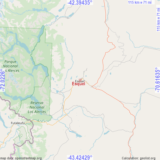
Esquel GPS coordinates[2]
42° 54' 41.292" South, 71° 19' 10.092" West
| Map corner | latitude | longitude |
|---|---|---|
| Upper-left | -42.39435°, | -72.0226° |
| Center: | -42.91147°, | -71.31947° |
| Lower-right: | -43.42429°, | -70.61635° |
| Map W x H: | 114.5×114.5 km | = 71.1×71.1mi |
| max Lat: | -21.94467° ⇑96.4% North |
| Esquel: | -42.91147° |
| min Lat: | ⇓3.6% South -54.81084° |
| min Long | Esquel | max Long |
| -72.88605° | -71.31947° | -53.64581° |
| W 1.3%⇐ | ⇒98.7% E |
Elevation
Elevation of Esquel is 577 m = 1893 ft, and this is 227.7 m = 747 ft above average elevation for this country.
| Max E: |
4040 m = 13255 ft | 19.3% |
| Esquel | 577 m 1893 ft | |
| Avg. | 349.3 m = 1146 ft | |
Min E: |
-2 m = -7 ft | 80.7% |
See also: Argentina elevation on elevation.city.
Geographical zone
Esquel is located in South temperate zone (between Tropic of Capricorn and the Antarctic Circle). Distance of this Southern Tropic circle is 2165.4 km =1345.5 mi to North.| Distance of | km | miles | from Esquel |
|---|---|---|---|
| Equator | 4771.3 | 2964.7 | to North |
| Tropic Capricorn | 2165.4 | 1345.5 | to North |
| Antarctic Circle | 2629.9 | 1634.1 | to South |
| South Pole | 5235.8 | 3253.4 | to South |


Nearby cities:
15 places around Esquel: (largest is in red/bold)
• El Bolsón
107.2 km =66.6 mi,  350°
350°
• El Maitén
96.7 km =60.1 mi,  7°
7°
• Gastre
186.3 km =115.8 mi,  67°
67°
• Gobernador Costa
139.3 km =86.6 mi,  155°
155°
• Hoyo de Epuyén
94.6 km =58.8 mi, 350°
• José de San Martín
144 km =89.5 mi,  151°
151°
• Lago Puelo
96.8 km =60.1 mi, 346°
• Leleque
59.2 km =36.8 mi,  20°
20°
• Paso de Indios
211.9 km =131.7 mi,  119°
119°
• Pilcaniyeu
204.9 km =127.3 mi, 13°
• Río Pico
141 km =87.6 mi,  181°
181°
• San Carlos de Bariloche
196.4 km =122 mi,  0°
0°
• Tecka
76.9 km =47.8 mi, 147°
• Trevelin
22.7 km =14.1 mi,  211°
211°
• Ñorquinco
122.8 km =76.3 mi, 16°
Sources, notices
• [Note1] Compared only with cities in Argentina existing in our database
• [Src1] Map data: © OpenStreetMap contributors (CC-BY-SA)
• [Src2] Other city data from geonames.org with taken over terms of usage.
• [Src3] Geographical zone / Annual Mean Temperature by Robert A. Rohde @ Wikipedia
