Lago Puelo geodata
Lago Puelo (Chubut) is a populated place; located in Argentina in America/Argentina/Catamarca (GMT-3) time zone. With population of 4,046 people, there are 488 cities with bigger population in this country. Compared to other cities in Argentina, 95.8% of cities are located further ↑North; 99.3% of cities are located further →East and 59.3% of cities have lower elevation than Lago Puelo. Note1


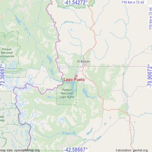
Lago Puelo GPS coordinates[2]
42° 4' 0.624" South, 71° 36' 13.824" West
| Map corner | latitude | longitude |
|---|---|---|
| Upper-left | -41.54272°, | -72.30697° |
| Center: | -42.06684°, | -71.60384° |
| Lower-right: | -42.58667°, | -70.90072° |
| Map W x H: | 116.1×116.1 km | = 72.1×72.1mi |
| max Lat: | -21.94467° ⇑95.8% North |
| Lago Puelo: | -42.06684° |
| min Lat: | ⇓4.2% South -54.81084° |
| min Long | Lago Puelo | max Long |
| -72.88605° | -71.60384° | -53.64581° |
| W 0.7%⇐ | ⇒99.3% E |
Elevation
Elevation of Lago Puelo is 207 m = 679 ft, and this is 142.3 m = 467 ft below average elevation for this country.
| Max E: |
4040 m = 13255 ft | 40.7% |
| Avg. | 349.3 m = 1146 ft | |
| Lago Puelo | 207 m = 679 ft | |
Min E: |
-2 m = -7 ft | 59.3% |
See also: Argentina elevation on elevation.city.
Geographical zone
Lago Puelo is located in South temperate zone (between Tropic of Capricorn and the Antarctic Circle). Distance of this Southern Tropic circle is 2071.5 km =1287.2 mi to North.| Distance of | km | miles | from Lago Puelo |
|---|---|---|---|
| Equator | 4677.4 | 2906.4 | to North |
| Tropic Capricorn | 2071.5 | 1287.2 | to North |
| Antarctic Circle | 2723.8 | 1692.5 | to South |
| South Pole | 5329.7 | 3311.7 | to South |


Nearby cities:
15 places around Lago Puelo: (largest is in red/bold)
• Comallo
160.2 km =99.5 mi,  43°
43°
• El Bolsón
13.2 km =8.2 mi,  26°
26°
• El Maitén
36.1 km =22.4 mi,  86°
86°
• Esquel
96.8 km =60.1 mi,  166°
166°
• Gastre
197.6 km =122.8 mi,  96°
96°
• Hoyo de Epuyén
7.9 km =4.9 mi, 94°
• Ingeniero Jacobacci
189.2 km =117.6 mi,  64°
64°
• Leleque
58.5 km =36.4 mi,  131°
131°
• Pilcaniyeu
128.1 km =79.6 mi, 34°
• San Carlos de Bariloche
105.3 km =65.4 mi,  13°
13°
• San Martín de los Andes
213.3 km =132.5 mi, 5°
• Tecka
171.5 km =106.6 mi,  157°
157°
• Trevelin
113.9 km =70.8 mi, 174°
• Villa La Angostura
145.2 km =90.2 mi,  358°
358°
• Ñorquinco
62.8 km =39 mi,  67°
67°
Sources, notices
• [Note1] Compared only with cities in Argentina existing in our database
• [Src1] Map data: © OpenStreetMap contributors (CC-BY-SA)
• [Src2] Other city data from geonames.org with taken over terms of usage.
• [Src3] Geographical zone / Annual Mean Temperature by Robert A. Rohde @ Wikipedia
