Trevelin geodata
Trevelin (Chubut) is a populated place; located in Argentina in America/Argentina/Catamarca (GMT-3) time zone. With population of 6,395 people, there are 390 cities with bigger population in this country. Compared to other cities in Argentina, 96.5% of cities are located further ↑North; 99% of cities are located further →East and 72.6% of cities have lower elevation than Trevelin. Note1


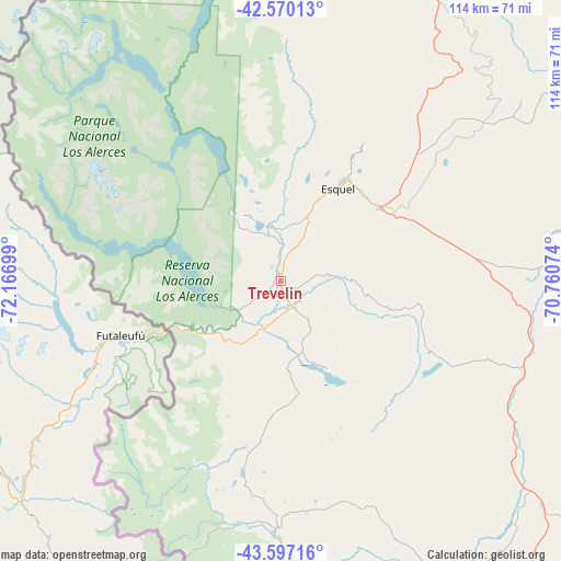
Trevelin GPS coordinates[2]
43° 5' 8.88" South, 71° 27' 49.896" West
| Map corner | latitude | longitude |
|---|---|---|
| Upper-left | -42.57013°, | -72.16699° |
| Center: | -43.0858°, | -71.46386° |
| Lower-right: | -43.59716°, | -70.76074° |
| Map W x H: | 114.2×114.2 km | = 71×71mi |
| max Lat: | -21.94467° ⇑96.5% North |
| Trevelin: | -43.0858° |
| min Lat: | ⇓3.5% South -54.81084° |
| min Long | Trevelin | max Long |
| -72.88605° | -71.46386° | -53.64581° |
| W 1%⇐ | ⇒99% E |
Elevation
Elevation of Trevelin is 380 m = 1247 ft, and this is 30.7 m = 101 ft above average elevation for this country.
| Max E: |
4040 m = 13255 ft | 27.4% |
| Trevelin | 380 m 1247 ft | |
| Avg. | 349.3 m = 1146 ft | |
Min E: |
-2 m = -7 ft | 72.6% |
See also: Argentina elevation on elevation.city.
Geographical zone
Trevelin is located in South temperate zone (between Tropic of Capricorn and the Antarctic Circle). Distance of this Southern Tropic circle is 2184.8 km =1357.6 mi to North.| Distance of | km | miles | from Trevelin |
|---|---|---|---|
| Equator | 4790.7 | 2976.8 | to North |
| Tropic Capricorn | 2184.8 | 1357.6 | to North |
| Antarctic Circle | 2610.5 | 1622.1 | to South |
| South Pole | 5216.4 | 3241.3 | to South |


Nearby cities:
15 places around Trevelin: (largest is in red/bold)
• Alto Río Senguer
223.4 km =138.8 mi,  166°
166°
• El Bolsón
125.3 km =77.9 mi,  357°
357°
• El Maitén
117.8 km =73.2 mi,  11°
11°
• Esquel
22.7 km =14.1 mi,  31°
31°
• Gastre
204.9 km =127.3 mi,  63°
63°
• Gobernador Costa
127.9 km =79.5 mi,  146°
146°
• Hoyo de Epuyén
112.8 km =70.1 mi, 358°
• José de San Martín
133.9 km =83.2 mi,  143°
143°
• Lago Puelo
113.9 km =70.8 mi,  354°
354°
• Leleque
81.6 km =50.7 mi,  23°
23°
• Paso de Indios
213.3 km =132.5 mi,  113°
113°
• Río Pico
121.8 km =75.7 mi,  176°
176°
• San Carlos de Bariloche
216.1 km =134.3 mi,  3°
3°
• Tecka
69.8 km =43.4 mi,  130°
130°
• Ñorquinco
144.9 km =90 mi, 18°
Sources, notices
• [Note1] Compared only with cities in Argentina existing in our database
• [Src1] Map data: © OpenStreetMap contributors (CC-BY-SA)
• [Src2] Other city data from geonames.org with taken over terms of usage.
• [Src3] Geographical zone / Annual Mean Temperature by Robert A. Rohde @ Wikipedia
