Pehuajó geodata
Pehuajó (Buenos Aires) is a seat of a second-order administrative division; located in Argentina in America/Argentina/Buenos_Aires (GMT-3) time zone. In our database, there are 785 cities with bigger population. Compared to other cities in Argentina, 81.1% of cities are located further ↑North; 55.7% of cities are located further ←West and 66.7% of cities have higher elevation than Pehuajó. Note1


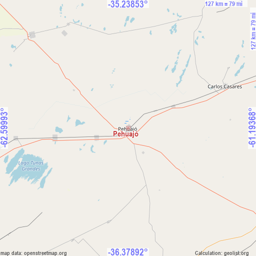
Pehuajó GPS coordinates[2]
35° 48' 38.772" South, 61° 53' 48.48" West
| Map corner | latitude | longitude |
|---|---|---|
| Upper-left | -35.23853°, | -62.59993° |
| Center: | -35.81077°, | -61.8968° |
| Lower-right: | -36.37892°, | -61.19368° |
| Map W x H: | 126.8×126.8 km | = 78.8×78.8mi |
| max Lat: | -21.94467° ⇑81.1% North |
| Pehuajó: | -35.81077° |
| min Lat: | ⇓18.9% South -54.81084° |
| min Long | Pehuajó | max Long |
| -72.88605° | -61.8968° | -53.64581° |
| W 55.7%⇐ | ⇒44.3% E |
Elevation
Elevation of Pehuajó is 89 m = 292 ft, and this is 260.3 m = 854 ft below average elevation for this country.
| Max E: |
4040 m = 13255 ft | 66.7% |
| Avg. | 349.3 m = 1146 ft | |
| Pehuajó | 89 m = 292 ft | |
Min E: |
-2 m = -7 ft | 33.3% |
See also: Argentina elevation on elevation.city.
Geographical zone
Pehuajó is located in South temperate zone (between Tropic of Capricorn and the Antarctic Circle). Distance of this Southern Tropic circle is 1375.9 km =854.9 mi to North.| Distance of | km | miles | from Pehuajó |
|---|---|---|---|
| Equator | 3981.8 | 2474.2 | to North |
| Tropic Capricorn | 1375.9 | 854.9 | to North |
| Antarctic Circle | 3419.4 | 2124.7 | to South |
| South Pole | 6025.3 | 3743.9 | to South |


Nearby cities:
15 places around Pehuajó: (largest is in red/bold)
• Carlos Casares
52.7 km =32.7 mi,  66°
66°
• Carlos Tejedor
66.4 km =41.3 mi,  314°
314°
• Daireaux
88.7 km =55.1 mi,  171°
171°
• Florentino Ameghino
119.3 km =74.1 mi,  334°
334°
• General Pinto
116.3 km =72.3 mi,  0°
0°
• General Viamonte
119.3 km =74.1 mi,  40°
40°
• General Villegas
133 km =82.6 mi, 310°
• Henderson
56.8 km =35.3 mi,  163°
163°
• Lincoln
110.1 km =68.4 mi,  17°
17°
• Nueve de Julio
100.3 km =62.3 mi, 66°
• Pellegrini
124.8 km =77.5 mi,  246°
246°
• San Carlos de Bolívar
84.3 km =52.4 mi,  123°
123°
• Trenque Lauquen
77.5 km =48.2 mi,  256°
256°
• Tres Algarrobos
104.9 km =65.2 mi, 310°
• Tres Lomas
112.5 km =69.9 mi,  230°
230°
Sources, notices
• [Note1] Compared only with cities in Argentina existing in our database
• [Src1] Map data: © OpenStreetMap contributors (CC-BY-SA)
• [Src2] Other city data from geonames.org with taken over terms of usage.
• [Src3] Geographical zone / Annual Mean Temperature by Robert A. Rohde @ Wikipedia
