General Levalle geodata
General Levalle (Cordoba) is a populated place; located in Argentina in America/Argentina/Cordoba (GMT-3) time zone. With population of 5,492 people, there are 421 cities with bigger population in this country. Compared to other cities in Argentina, 68.9% of cities are located further ↑North; 60.2% of cities are located further →East and 56.4% of cities have lower elevation than General Levalle. Note1


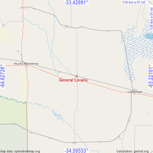
General Levalle GPS coordinates[2]
34° 0' 52.992" South, 63° 55' 26.868" West
| Map corner | latitude | longitude |
|---|---|---|
| Upper-left | -33.42991°, | -64.62726° |
| Center: | -34.01472°, | -63.92413° |
| Lower-right: | -34.59553°, | -63.22101° |
| Map W x H: | 129.6×129.6 km | = 80.5×80.5mi |
| max Lat: | -21.94467° ⇑68.9% North |
| General Levalle: | -34.01472° |
| min Lat: | ⇓31.1% South -54.81084° |
| min Long | General Levalle | max Long |
| -72.88605° | -63.92413° | -53.64581° |
| W 39.8%⇐ | ⇒60.2% E |
Elevation
Elevation of General Levalle is 180 m = 591 ft, and this is 169.3 m = 555 ft below average elevation for this country.
| Max E: |
4040 m = 13255 ft | 43.6% |
| Avg. | 349.3 m = 1146 ft | |
| General Levalle | 180 m = 591 ft | |
Min E: |
-2 m = -7 ft | 56.4% |
See also: Argentina elevation on elevation.city.
Geographical zone
General Levalle is located in South temperate zone (between Tropic of Capricorn and the Antarctic Circle). Distance of this Southern Tropic circle is 1176.2 km =730.9 mi to North.| Distance of | km | miles | from General Levalle |
|---|---|---|---|
| Equator | 3782.1 | 2350.1 | to North |
| Tropic Capricorn | 1176.2 | 730.9 | to North |
| Antarctic Circle | 3619.1 | 2248.8 | to South |
| South Pole | 6225 | 3868 | to South |


Nearby cities:
15 places around General Levalle: (largest is in red/bold)
• Adelia María
43.5 km =27 mi,  348°
348°
• Alejandro Roca
75.9 km =47.2 mi,  14°
14°
• Buchardo
87.4 km =54.3 mi,  154°
154°
• Coronel Moldes
75.9 km =47.2 mi,  305°
305°
• Del Campillo
66.1 km =41.1 mi,  232°
232°
• Huanchillas
46.9 km =29.1 mi,  34°
34°
• Italó
87.4 km =54.3 mi,  171°
171°
• Laboulaye
50.6 km =31.4 mi,  104°
104°
• Las Acequias
81.7 km =50.8 mi,  356°
356°
• Mattaldi
56.7 km =35.2 mi,  203°
203°
• San Basilio
67.9 km =42.2 mi,  327°
327°
• Santa Magdalena
56 km =34.8 mi,  181°
181°
• Serrano
61.8 km =38.4 mi,  144°
144°
• Viamonte
81.9 km =50.9 mi,  68°
68°
• Vicuña Mackenna
44.4 km =27.6 mi,  283°
283°
Sources, notices
• [Note1] Compared only with cities in Argentina existing in our database
• [Src1] Map data: © OpenStreetMap contributors (CC-BY-SA)
• [Src2] Other city data from geonames.org with taken over terms of usage.
• [Src3] Geographical zone / Annual Mean Temperature by Robert A. Rohde @ Wikipedia
