Alejandro Roca geodata
Alejandro Roca (Cordoba) is a populated place; located in Argentina in America/Argentina/Cordoba (GMT-3) time zone. With population of 4,724 people, there are 453 cities with bigger population in this country. Compared to other cities in Argentina, 65.6% of cities are located further ↑North; 57.9% of cities are located further →East and 60.4% of cities have lower elevation than Alejandro Roca. Note1


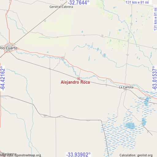
Alejandro Roca GPS coordinates[2]
33° 21' 13.284" South, 63° 43' 6.564" West
| Map corner | latitude | longitude |
|---|---|---|
| Upper-left | -32.7644°, | -64.42162° |
| Center: | -33.35369°, | -63.71849° |
| Lower-right: | -33.93902°, | -63.01537° |
| Map W x H: | 130.6×130.6 km | = 81.2×81.2mi |
| max Lat: | -21.94467° ⇑65.6% North |
| Alejandro Roca: | -33.35369° |
| min Lat: | ⇓34.4% South -54.81084° |
| min Long | Alejandro Roca | max Long |
| -72.88605° | -63.71849° | -53.64581° |
| W 42.1%⇐ | ⇒57.9% E |
Elevation
Elevation of Alejandro Roca is 216 m = 709 ft, and this is 133.3 m = 437 ft below average elevation for this country.
| Max E: |
4040 m = 13255 ft | 39.6% |
| Avg. | 349.3 m = 1146 ft | |
| Alejandro Roca | 216 m = 709 ft | |
Min E: |
-2 m = -7 ft | 60.4% |
See also: Argentina elevation on elevation.city.
Geographical zone
Alejandro Roca is located in South temperate zone (between Tropic of Capricorn and the Antarctic Circle). Distance of this Southern Tropic circle is 1102.7 km =685.2 mi to North.| Distance of | km | miles | from Alejandro Roca |
|---|---|---|---|
| Equator | 3708.6 | 2304.4 | to North |
| Tropic Capricorn | 1102.7 | 685.2 | to North |
| Antarctic Circle | 3692.6 | 2294.5 | to South |
| South Pole | 6298.5 | 3913.7 | to South |


Nearby cities:
15 places around Alejandro Roca: (largest is in red/bold)
• Adelia María
41.7 km =25.9 mi,  222°
222°
• Carnerillo
56.5 km =35.1 mi,  330°
330°
• Charras
47.7 km =29.6 mi,  320°
320°
• Chazón
51.2 km =31.8 mi,  53°
53°
• Etruria
63.6 km =39.5 mi,  43°
43°
• General Cabrera
61.8 km =38.4 mi,  346°
346°
• Huanchillas
35.6 km =22.1 mi,  167°
167°
• La Carlota
39.8 km =24.7 mi,  100°
100°
• Las Acequias
25.2 km =15.7 mi,  288°
288°
• Las Higueras
60.5 km =37.6 mi,  298°
298°
• Río Cuarto
63.7 km =39.6 mi, 292°
• San Basilio
57.6 km =35.8 mi,  253°
253°
• Santa Eufemia
45 km =28 mi,  64°
64°
• Ucacha
40.8 km =25.4 mi,  28°
28°
• Villa Reducción
21.6 km =13.4 mi, 321°
Sources, notices
• [Note1] Compared only with cities in Argentina existing in our database
• [Src1] Map data: © OpenStreetMap contributors (CC-BY-SA)
• [Src2] Other city data from geonames.org with taken over terms of usage.
• [Src3] Geographical zone / Annual Mean Temperature by Robert A. Rohde @ Wikipedia
